
Spenden
Rüsten Sie sich für Ihr nächstes Abenteuer:
Als Amazon-Partner erhält diese Website eine Provision für qualifizierte Käufe, ohne zusätzliche Kosten für Sie.
Topografische Karte Le Hingleuf
Klicken Sie auf die Karte, um die Höhe anzuzeigen.
Spenden
Rüsten Sie sich für Ihr nächstes Abenteuer:
Als Amazon-Partner erhält diese Website eine Provision für qualifizierte Käufe, ohne zusätzliche Kosten für Sie.
Über diese Karte
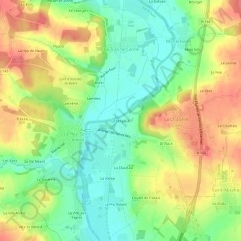
Name: Topografische Karte Le Hingleuf, Höhe, Relief.
Durchschnittliche Höhe: 47 m
Minimale Höhe: 12 m
Maximale Höhe: 88 m
Spenden
Rüsten Sie sich für Ihr nächstes Abenteuer:
Als Amazon-Partner erhält diese Website eine Provision für qualifizierte Käufe, ohne zusätzliche Kosten für Sie.
Andere topografische Karten
Klicken Sie auf eine Karte, um ihre Topografie, ihre Höhe und ihr Relief anzuzeigen.
La Chapelle-Caro
France > Bretagne > Morbihan > Val d'Oust
Le relief de cette ancienne commune présente une pente générale vers l'ouest en direction de la vallée de l'Oust ; le dénivelé est notable entre le point le plus haut (116 mètres d'altitude) situé dans l'angle nord-est de son finage (au sud du lieu-dit La Boare) et la vallée de l'Oust (17 mètres…
Durchschnittliche Höhe: 56 m
Le Roc-Saint-André
France > Bretagne > Morbihan > Val d'Oust
Le finage du Roc-Saint-André est constitué de deux parties très différentes : d'une part les trois quarts ouest de cette ancienne commune sont un plateau (formé de petites collines séparées par des ruisseaux qui vont se jeter dans l'Oust) situé en moyenne entre 80 mètres et 100 mètres d'altitude,…
Durchschnittliche Höhe: 50 m