
Topografische Karte Spello
Interaktive Karte
Klicken Sie auf die Karte, um die Höhe anzuzeigen.
Über diese Karte
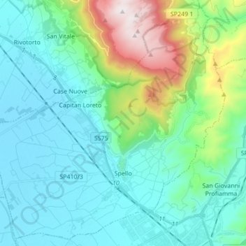
Name: Topografische Karte Spello, Höhe, Relief.
Ort: Spello, Perugia, Umbria, 06038, Italy (42.96411 12.59149 43.05836 12.72863)
Durchschnittliche Höhe: 412 m
Minimale Höhe: 185 m
Maximale Höhe: 1.288 m
Andere topografische Karten
Klicken Sie auf eine Karte, um ihre Topografie, ihre Höhe und ihr Relief anzuzeigen.
San Pietro
Italy > Umbria > Perugia > Corciano
San Pietro, Corciano, Perugia, Umbria, 06073, Italy
Durchschnittliche Höhe: 264 m
San Giorgio
Italy > Umbria > Perugia > Cascia
San Giorgio, Cascia, Perugia, Umbria, 06043, Italy
Durchschnittliche Höhe: 786 m
Fratticiola Selvatica
Italy > Umbria > Perugia > Perugia
Fratticiola Selvatica, Perugia, Umbria, Italy
Durchschnittliche Höhe: 503 m
Città di Castello
Italy > Umbria > Perugia > Città di Castello
Città di Castello, Perugia, Umbria, Italy
Durchschnittliche Höhe: 504 m
Giano dell'Umbria
Italy > Umbria > Perugia > Giano dell'Umbria
Giano dell'Umbria, Perugia, Umbria, 06030, Italy
Durchschnittliche Höhe: 470 m
Compignano
Italy > Umbria > Perugia > Marsciano
Compignano, Marsciano, Perugia, Umbria, 06055, Italy
Durchschnittliche Höhe: 234 m