
Topografische Karte Trevi
Interaktive Karte
Klicken Sie auf die Karte, um die Höhe anzuzeigen.
Trevi
The natural environment of the territory as a whole remains largely unspoiled, this despite being significantly populated for millennia. The mountainous area is now witnessing a considerable depopulation — as elsewhere in Italy, in the second half of the 20th century settlements at the highest elevations have been rapidly losing their inhabitants to the plains. The most important growth areas since the period following World War II have been Borgo Trevi (commercial, residential, and offices), Pietrarossa (industrial), and Matigge (light and medium industry, commercial).
Über diese Karte
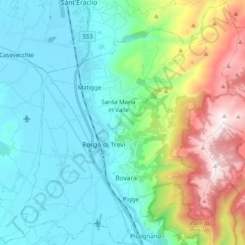
Name: Topografische Karte Trevi, Höhe, Relief.
Ort: Trevi, Perugia, Umbria, 06039, Italy (42.83403 12.69013 42.93376 12.82816)
Durchschnittliche Höhe: 507 m
Minimale Höhe: 200 m
Maximale Höhe: 1.418 m
Andere topografische Karten
Klicken Sie auf eine Karte, um ihre Topografie, ihre Höhe und ihr Relief anzuzeigen.
Ponticelli
Ponticelli is a frazione of the comune of Città della Pieve in the Province of Perugia, Umbria, central Italy. It stands at an elevation of 249 metres above sea level. At the time of the Istat census of 2001 it had 610 inhabitants.
Durchschnittliche Höhe: 275 m