
Topografische Karte Rüdesheim
Interaktive Karte
Klicken Sie auf die Karte, um die Höhe anzuzeigen.
Über diese Karte
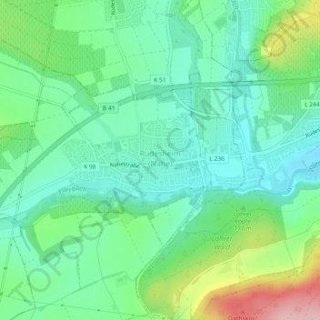
Name: Topografische Karte Rüdesheim, Höhe, Relief.
Durchschnittliche Höhe: 165 m
Minimale Höhe: 111 m
Maximale Höhe: 300 m
Rüdesheim lies in the transitional zone between Rhenish Hesse and the Hunsrück at the mouth of the Katzenbach, where it empties into the Ellerbach, itself a tributary to the Nahe. Although that river lies a short way outside Rüdesheim, the municipality still styles itself “an der Nahe” (“on the Nahe”) and claims that it lies im Herzen des wunderschönen Nahetals (“in the heart of the wonderfully lovely Nahe valley”). The village is found some 4 km west of the district seat of Bad Kreuznach, with which it has all but grown together into one built-up area. The village sits at an elevation of 135 m above sea level. The municipal area measures 3.47 km².
Andere topografische Karten
Klicken Sie auf eine Karte, um ihre Topografie, ihre Höhe und ihr Relief anzuzeigen.
Bärweiler
Germany > Rhineland-Palatinate > Landkreis Bad Kreuznach
Bärweiler, Nahe-Glan, Landkreis Bad Kreuznach, Rhineland-Palatinate, Germany
Durchschnittliche Höhe: 327 m
Langenthal
Germany > Rhineland-Palatinate > Landkreis Bad Kreuznach
Langenthal, Nahe-Glan, Landkreis Bad Kreuznach, Rhineland-Palatinate, Germany
Durchschnittliche Höhe: 319 m
Rheingrafenstein
Germany > Rhineland-Palatinate > Landkreis Bad Kreuznach > Bad Kreuznach
Rheingrafenstein, Bad Kreuznach, Landkreis Bad Kreuznach, Rhineland-Palatinate, 55583, Germany
Durchschnittliche Höhe: 218 m