
Topografische Karte Bärweiler
Interaktive Karte
Klicken Sie auf die Karte, um die Höhe anzuzeigen.
Bärweiler
Bärweiler lies in picturesque hilly land between Bad Sobernheim and Meisenheim. The residential community characterized by agriculture has a municipal area measuring 611 ha. The municipality lies 10 km from Bad Sobernheim, 13 km from Kirn, 10 km from Meisenheim and roughly 30 km from the district seat, Bad Kreuznach. The village, which lies south of the Nahe, belongs to the northernmost part of the Saar-Nahe Uplands and Hills, more precisely to the Sien-Lauschied Ridge in the Meisenheim Uplands (Glan-Alsenz Mountains). Because of the lively breaking-up of the landscape into scattered, wooded hillocks and ridges, hollows and open plateau remnants, the countryside is also described as “humpy land”. The highest elevation in the municipality reaches 393.0 m above sea level, while the lowest point is 225.3 m above sea level.
Über diese Karte
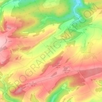
Name: Topografische Karte Bärweiler, Höhe, Relief.
Durchschnittliche Höhe: 327 m
Minimale Höhe: 208 m
Maximale Höhe: 404 m