
Topografische Karte Peerless Lake
Interaktive Karte
Klicken Sie auf die Karte, um die Höhe anzuzeigen.
Über diese Karte
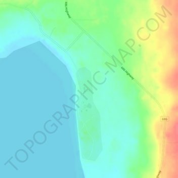
Name: Topografische Karte Peerless Lake, Höhe, Relief.
Durchschnittliche Höhe: 703 m
Minimale Höhe: 687 m
Maximale Höhe: 745 m
Peerless Lake is an unincorporated community in northern Alberta, Canada. It is located on the northeastern shore of Peerless Lake, approximately 70 kilometres (43 mi) northeast of Red Earth Creek, and has an elevation of 695 metres (2,280 ft).
Andere topografische Karten
Klicken Sie auf eine Karte, um ihre Topografie, ihre Höhe und ihr Relief anzuzeigen.
Calling Lake
Canada > Alberta > Municipal District of Opportunity > Calling Lake
Calling Lake, Municipal District of Opportunity, Alberta, T0G 0K0, Canada
Durchschnittliche Höhe: 609 m
Red Earth Creek
Canada > Alberta > Municipal District of Opportunity > Red Earth Creek
Red Earth Creek, Municipal District of Opportunity, Alberta, T0G 1X0, Canada
Durchschnittliche Höhe: 549 m
Wabasca-Desmarais
Canada > Alberta > Municipal District of Opportunity > Wabasca-Desmarais
Wabasca-Desmarais, Municipal District of Opportunity, Alberta, T0G 2K0, Canada
Durchschnittliche Höhe: 556 m