
Topografische Karte Union
Interaktive Karte
Klicken Sie auf die Karte, um die Höhe anzuzeigen.
Über diese Karte
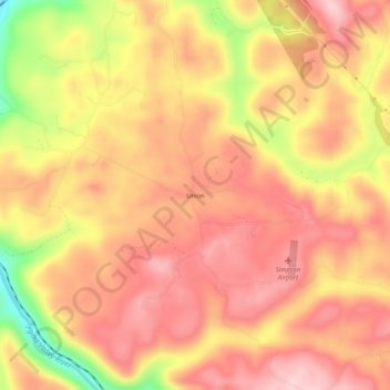
Name: Topografische Karte Union, Höhe, Relief.
Ort: Union, Barbour County, West Virginia, United States (39.08010 -80.05814 39.12010 -80.01814)
Durchschnittliche Höhe: 545 m
Minimale Höhe: 400 m
Maximale Höhe: 619 m
Andere topografische Karten
Klicken Sie auf eine Karte, um ihre Topografie, ihre Höhe und ihr Relief anzuzeigen.
Volga
United States > West Virginia > Barbour County
Volga, Barbour County, West Virginia, 26238, United States
Durchschnittliche Höhe: 460 m
Moatsville
United States > West Virginia > Barbour County
Moatsville, Barbour County, West Virginia, 26405, United States
Durchschnittliche Höhe: 476 m
Galloway
United States > West Virginia > Barbour County
Galloway, Barbour County, West Virginia, 26349, United States
Durchschnittliche Höhe: 403 m
Century Junction
United States > West Virginia > Barbour County
Century Junction, Barbour County, West Virginia, 26238, United States
Durchschnittliche Höhe: 456 m
Belington
United States > West Virginia > Barbour County
Belington, Barbour County, West Virginia, 26250, United States
Durchschnittliche Höhe: 542 m
Independence
United States > West Virginia > Barbour County > Independence
Independence, Barbour County, West Virginia, 26416, United States
Durchschnittliche Höhe: 501 m
Junior
United States > West Virginia > Barbour County
Junior, Barbour County, West Virginia, 26275, United States
Durchschnittliche Höhe: 587 m
Philippi
United States > West Virginia > Barbour County
Philippi, Barbour County, West Virginia, 26416, United States
Durchschnittliche Höhe: 490 m