
Topografische Karte Philippi
Interaktive Karte
Klicken Sie auf die Karte, um die Höhe anzuzeigen.
Über diese Karte
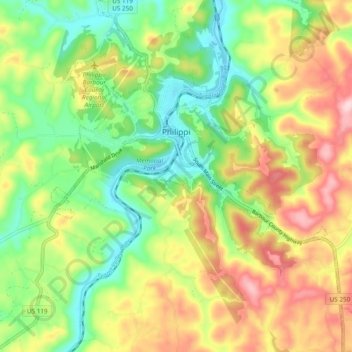
Name: Topografische Karte Philippi, Höhe, Relief.
Durchschnittliche Höhe: 490 m
Minimale Höhe: 388 m
Maximale Höhe: 626 m
Throughout its history, Philippi has suffered from floods because of its proximity to the river and the relatively low elevation of most of the town. The most damaging of these came in November 1985. The town has since adopted a flood plain management plan.
Andere topografische Karten
Klicken Sie auf eine Karte, um ihre Topografie, ihre Höhe und ihr Relief anzuzeigen.
Volga
United States > West Virginia > Barbour County
Volga, Barbour County, West Virginia, 26238, United States
Durchschnittliche Höhe: 460 m
Moatsville
United States > West Virginia > Barbour County
Moatsville, Barbour County, West Virginia, 26405, United States
Durchschnittliche Höhe: 476 m
Galloway
United States > West Virginia > Barbour County
Galloway, Barbour County, West Virginia, 26349, United States
Durchschnittliche Höhe: 403 m
Century Junction
United States > West Virginia > Barbour County
Century Junction, Barbour County, West Virginia, 26238, United States
Durchschnittliche Höhe: 456 m
Union
United States > West Virginia > Barbour County
Union, Barbour County, West Virginia, United States
Durchschnittliche Höhe: 545 m
Belington
United States > West Virginia > Barbour County
Belington, Barbour County, West Virginia, 26250, United States
Durchschnittliche Höhe: 542 m
Independence
United States > West Virginia > Barbour County > Independence
Independence, Barbour County, West Virginia, 26416, United States
Durchschnittliche Höhe: 501 m
Junior
United States > West Virginia > Barbour County
Junior, Barbour County, West Virginia, 26275, United States
Durchschnittliche Höhe: 587 m