Geolokalisieren

Topografische Karte Nashik

Klicken Sie auf die Karte, um die Höhe anzuzeigen.

Über diese Karte

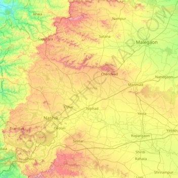
Name: Topografische Karte Nashik, Höhe, Relief.

Ort: Nashik, Maharashtra, India (19.51667 73.38333 20.91667 74.78333)

Durchschnittliche Höhe: 555 m

Minimale Höhe: 72 m

Maximale Höhe: 1.562 m

Andere topografische Karten

Klicken Sie auf eine Karte, um ihre Topografie, ihre Höhe und ihr Relief anzuzeigen.

Mumbai

India > Maharashtra > Mumbai

Mumbai is on a narrow peninsula on the southwest of Salsette Island, which lies between the Arabian Sea to the west, Thane Creek to the east and Vasai Creek to the north. Mumbai's suburban district occupies most of the island. Navi Mumbai is east of Thane Creek and Thane is north of Vasai Creek. Mumbai…

Durchschnittliche Höhe: 18 m

Mumbai

India > Maharashtra

Mumbai is on a narrow peninsula on the southwest of Salsette Island, which lies between the Arabian Sea to the west, Thane Creek to the east and Vasai Creek to the north. Mumbai's suburban district occupies most of the island. Navi Mumbai is east of Thane Creek and Thane is north of Vasai Creek. Mumbai…

Durchschnittliche Höhe: 18 m

Pune City

India > Maharashtra

Pune lies on the western margin of the Deccan plateau, at an altitude of 560 m (1,840 ft) above sea level. It is on the leeward side of the Sahyadri mountain range, which forms a barrier from the Arabian Sea. It is a hilly city, with Vetal Hill rising to 800 m (2,600 ft) above sea level. The Sinhagad fort is…

Durchschnittliche Höhe: 616 m

Dindori Taluka

India > Maharashtra

Durchschnittliche Höhe: 671 m

Raigad

India > Maharashtra

Durchschnittliche Höhe: 237 m

Nanded District

India > Maharashtra

Nanded is bounded on the north by Yavatmal district of the Vidarbha region, with Latur on south-west, Parbhani and Hingoli districts on the west. On the eastern side lies Adilabad, Nirmal, Nizamabad and Kamareddy districts of Telangana state, and on the south lies Bidar of Karnataka state. The area presents…

Durchschnittliche Höhe: 432 m

Latur District

India > Maharashtra

Latur district is in the Marathwada region in Maharashtra in India, located between 17°52' North to 18°50' North and 76°18' East to 79°12' East in the Deccan plateau. It has an average elevation of 631 metres (2,070 ft) above mean sea level. The entire district of Latur is on the Balaghat plateau, 540 to…

Durchschnittliche Höhe: 590 m

Pune District

India > Maharashtra

Durchschnittliche Höhe: 521 m

Shevgaon

India > Maharashtra

Durchschnittliche Höhe: 493 m

Satara

India > Maharashtra

Durchschnittliche Höhe: 677 m

Mumbai

India > Maharashtra

Durchschnittliche Höhe: 25 m

Pune

India > Maharashtra

Pune is situated at approximately 18° 32" north latitude and 73° 51" east longitude. The city's total area is 15.642 km2, and the municipal corporation area covers 518 km2. By road Pune is 149 km (93 mi) south-east of Mumbai, 580 km (360 mi) south-west of Indore, 695 km (432 mi) west of Nagpur, 1,173 km (729…

Durchschnittliche Höhe: 616 m

Niphad Taluka

India > Maharashtra

Durchschnittliche Höhe: 585 m

Solapur District

India > Maharashtra

Durchschnittliche Höhe: 565 m

Paithan

India > Maharashtra

Paithan is located at 19°29′N 75°23′E / 19.48°N 75.38°E / 19.48; 75.38. It has an average elevation of 458 m (1,503 ft).

Durchschnittliche Höhe: 495 m

Hatkanangle

India > Maharashtra

Durchschnittliche Höhe: 574 m

Aundha (Nagnath)

India > Maharashtra

Durchschnittliche Höhe: 445 m

Akrani Taluka

India > Maharashtra

Durchschnittliche Höhe: 426 m

Rahuri

India > Maharashtra

Durchschnittliche Höhe: 563 m

Ahmednagar District

India > Maharashtra

Durchschnittliche Höhe: 596 m

Vielen Dank für die Unterstützung dieser Website ❤️
Spenden

Rüsten Sie sich für Ihr nächstes Abenteuer:

Als Amazon-Partner erhält diese Website eine Provision für qualifizierte Käufe, ohne zusätzliche Kosten für Sie.

Ratnagiri

India > Maharashtra

An outstanding feature of the geography of the district is its uneven or hill topography, with about 45% of the district being characterized as 'hilly'. Very narrow riverine plains fringe the coastline.

Durchschnittliche Höhe: 301 m

Haveli

India > Maharashtra

Durchschnittliche Höhe: 645 m

Yavatmal District

India > Maharashtra

Durchschnittliche Höhe: 328 m

Wardha

India > Maharashtra

Durchschnittliche Höhe: 313 m

Vielen Dank für die Unterstützung dieser Website ❤️
Spenden

Rüsten Sie sich für Ihr nächstes Abenteuer:

Als Amazon-Partner erhält diese Website eine Provision für qualifizierte Käufe, ohne zusätzliche Kosten für Sie.

Ambegaon

India > Maharashtra

Durchschnittliche Höhe: 703 m

Jalgaon District

India > Maharashtra

Durchschnittliche Höhe: 399 m

Panhala

India > Maharashtra

Panhala is located at 16°49′12″N 74°7′12″E / 16.82000°N 74.12000°E / 16.82000; 74.12000. It has an average elevation of 754 metres (2473 feet). Panhala is connected via train and bus to Kolhapur and Sangli. Kolhapur is about 21 km away while Sangli is about 60 km. Kolhapur Chhatrapati…

Durchschnittliche Höhe: 620 m

Shahuwadi

India > Maharashtra

Durchschnittliche Höhe: 601 m

Vielen Dank für die Unterstützung dieser Website ❤️
Spenden

Rüsten Sie sich für Ihr nächstes Abenteuer:

Als Amazon-Partner erhält diese Website eine Provision für qualifizierte Käufe, ohne zusätzliche Kosten für Sie.

Shahapur Taluka

India > Maharashtra

Durchschnittliche Höhe: 224 m

Mangrulpir

India > Maharashtra

Durchschnittliche Höhe: 463 m

Lonar

India > Maharashtra

Durchschnittliche Höhe: 541 m

Washim

India > Maharashtra

Durchschnittliche Höhe: 413 m

Vielen Dank für die Unterstützung dieser Website ❤️
Spenden

Rüsten Sie sich für Ihr nächstes Abenteuer:

Als Amazon-Partner erhält diese Website eine Provision für qualifizierte Käufe, ohne zusätzliche Kosten für Sie.

Bhor

India > Maharashtra

Durchschnittliche Höhe: 763 m

Nashik District

India > Maharashtra

The entire Nashik district is underlain by the basaltic lava flows. These flows are normally horizontally disposed over a wide stretch and give rise to table land type of topography also known as a plateau. These flows occur in layered sequences and represented by massive unit at the bottom and vesicular unit…

Durchschnittliche Höhe: 522 m

Bramhapuri Town

India > Maharashtra > Brahmapuri Taluka

Bramhapuri is one of the six divisions located in the northeastern part of Chandrapur district, Maharashtra at 20°22′N 79°31′E / 20.36°N 79.51°E / 20.36; 79.51 and has an average elevation of 229.5 metres (753 feet). The town is located in the 73rd Vidhan Sabha constituency in Maharashtra.

Durchschnittliche Höhe: 226 m

Navi Mumbai

India > Maharashtra > Thane Subdistrict

Navi Mumbai (Marathi pronunciation: [nəʋiː mumbəiː]), is a planned city situated on the west coast of the Indian subcontinent, located in the Konkan division of Maharashtra state, on the mainland of India. Navi Mumbai is part of the Mumbai Metropolitan Region (MMR). The city is divided into two, North…

Durchschnittliche Höhe: 22 m

Vielen Dank für die Unterstützung dieser Website ❤️
Spenden

Chopda

India > Maharashtra

Durchschnittliche Höhe: 306 m

Shirol

India > Maharashtra

Durchschnittliche Höhe: 555 m

Akkalkot

India > Maharashtra

Durchschnittliche Höhe: 478 m

Thane

India > Maharashtra > Thane Taluka

Durchschnittliche Höhe: 54 m

Vielen Dank für die Unterstützung dieser Website ❤️
Spenden

Ghatkopar Hill

India > Maharashtra > Mumbai

Durchschnittliche Höhe: 50 m

Mula-Mutha River

India > Maharashtra > Pune > Khadki

Durchschnittliche Höhe: 556 m

Kolhapur District

India > Maharashtra

Kolhapur experiences winter from November to February. The winter temperatures are warmer than other cities in Maharashtra such as Pune and Nashik. Lows range from 9 to 16 °C (48 to 61 °F) while highs are in the range of 24 to 32 °C (75 to 90 °F) due to its high elevation and being adjacent to the Western…

Durchschnittliche Höhe: 464 m

Chikhaldara

India > Maharashtra

The sole hill resort in the Vidarbha region, it is situated at an altitude of 1118 meters with highest elevation point 1188 meters and has the added dimension of being the only coffee-growing area in Maharashtra. Chikhaldara has an annual rainfall of 154cm. Temperatures vary from 39C in summer to 5C in winter.…

Durchschnittliche Höhe: 521 m

Akkalkuwa Taluka

India > Maharashtra

Durchschnittliche Höhe: 393 m

Ambejogai

India > Maharashtra

Durchschnittliche Höhe: 604 m

Sentosa Water Park

India > Maharashtra > Haveli > Ravet

Durchschnittliche Höhe: 577 m

Jamgaon

India > Maharashtra > Mehkar > Mehkar

Durchschnittliche Höhe: 556 m

Sangola

India > Maharashtra > Patur > Sangola

Durchschnittliche Höhe: 310 m

M/E Ward

India > Maharashtra > Mumbai

Durchschnittliche Höhe: 15 m

Khidki

India > Maharashtra > Dharni

Durchschnittliche Höhe: 426 m

Pohi

India > Maharashtra > Achalpur > Achalpur

Durchschnittliche Höhe: 351 m

KANHER

India > Maharashtra > Satara > Satara

Durchschnittliche Höhe: 686 m

Kondvil Beach

India > Maharashtra > Shrivardhan Taluka

Durchschnittliche Höhe: 16 m

Powai Naka

India > Maharashtra > Satara > Satara

Durchschnittliche Höhe: 692 m

Waki Dam

India > Maharashtra > Baramati

Durchschnittliche Höhe: 582 m

Vielen Dank für die Unterstützung dieser Website ❤️
Spenden

Mohadi Town

India > Maharashtra > Mohadi Taluka

Durchschnittliche Höhe: 260 m

Buldhana District

India > Maharashtra

Lonarkar Top (about 923 meters) is highest altitude in Buldhana District placed in Ambabarwa Wildlife Sanctuary.

Durchschnittliche Höhe: 425 m

Pune City

India > Maharashtra

Pune lies on the western margin of the Deccan plateau, at an altitude of 560 m (1,840 ft) above sea level. It is on the leeward side of the Sahyadri mountain range, which forms a barrier from the Arabian Sea. It is a hilly city, with Vetal Hill rising to 800 m (2,600 ft) above sea level. The Sinhagad fort is…

Durchschnittliche Höhe: 616 m

Purandhar

India > Maharashtra

Durchschnittliche Höhe: 694 m

Borgaon Manju

India > Maharashtra > Akola

Durchschnittliche Höhe: 295 m

Usara

India > Maharashtra > Mohadi Taluka

Durchschnittliche Höhe: 281 m

Chitri

India > Maharashtra > Dharni

Durchschnittliche Höhe: 424 m

Korlai Fort

India > Maharashtra > Murud Taluka > Korlai

Durchschnittliche Höhe: 2 m

Vielen Dank für die Unterstützung dieser Website ❤️
Spenden

Rüsten Sie sich für Ihr nächstes Abenteuer:

Als Amazon-Partner erhält diese Website eine Provision für qualifizierte Käufe, ohne zusätzliche Kosten für Sie.

Malur

India > Maharashtra > Dharni

Durchschnittliche Höhe: 381 m

Naldurg Fort

India > Maharashtra > Tuljapur > Naldurg

Durchschnittliche Höhe: 558 m

Shevgedang

India > Maharashtra > Igatpuri Taluka

Durchschnittliche Höhe: 626 m

Shedgewadi

India > Maharashtra > Man

Durchschnittliche Höhe: 902 m

Tuljapur

India > Maharashtra > Bhatkuli

Durchschnittliche Höhe: 315 m

Banda

India > Maharashtra > Lonar

Durchschnittliche Höhe: 561 m

Shahapur

India > Maharashtra > Bhandara Taluka

Durchschnittliche Höhe: 253 m

Paraswada

India > Maharashtra > Tumsar Taluka > Paraswada

Durchschnittliche Höhe: 272 m

Shahapur

India > Maharashtra > Amravati

Durchschnittliche Höhe: 389 m

Ambernath

India > Maharashtra > Ulhasnagar Subdistrict

Durchschnittliche Höhe: 55 m

Bhiwandi Subdistrict

India > Maharashtra

Durchschnittliche Höhe: 60 m

Amravati

India > Maharashtra

Durchschnittliche Höhe: 432 m

Vielen Dank für die Unterstützung dieser Website ❤️
Spenden

Bahula

India > Maharashtra > Pachora > Veruli Bk

Durchschnittliche Höhe: 253 m

Gadchiroli

India > Maharashtra

Durchschnittliche Höhe: 296 m

Palghar

India > Maharashtra

Durchschnittliche Höhe: 160 m

Dharavi

India > Maharashtra > Mumbai

Durchschnittliche Höhe: 6 m

Vielen Dank für die Unterstützung dieser Website ❤️
Spenden

Rüsten Sie sich für Ihr nächstes Abenteuer:

Als Amazon-Partner erhält diese Website eine Provision für qualifizierte Käufe, ohne zusätzliche Kosten für Sie.

Mutha

India > Maharashtra > Haveli > Sangrun

Durchschnittliche Höhe: 671 m

Raini (R)

India > Maharashtra > Bhandara Taluka

Durchschnittliche Höhe: 266 m

Pandharabodi

India > Maharashtra > Bhandara Taluka > Pandharabodi

Durchschnittliche Höhe: 261 m

Chandrapur

India > Maharashtra

Durchschnittliche Höhe: 230 m

Nagpur

India > Maharashtra > Nagpur Urban Taluka

Durchschnittliche Höhe: 307 m

Khatav

India > Maharashtra

Durchschnittliche Höhe: 757 m

Chandurbazar

India > Maharashtra

Durchschnittliche Höhe: 394 m

Shivaji Park

India > Maharashtra > Mumbai

Durchschnittliche Höhe: 7 m

Babhulgaon

India > Maharashtra > Akola > Babhulgaon

Durchschnittliche Höhe: 294 m

Taroda

India > Maharashtra > Dhamangaon Railway > Taroda

Durchschnittliche Höhe: 316 m

Patalganga

India > Maharashtra > Khalapur Taluka > Jambrung

Durchschnittliche Höhe: 95 m

Kagal

India > Maharashtra

Kagal is a taluka in Kolhapur district. It is located at the boundary of Maharashtra and Karnataka. The Chhatrapati Shahu Sahakari Sakar Karkhana is located here. The Dudhganga river passes through Kagal. Kagal is located at 16°35′N 74°19′E / 16.58°N 74.32°E / 16.58; 74.32. It has an average…

Durchschnittliche Höhe: 607 m

Chhatrapati Sambhajinagar District

India > Maharashtra

Durchschnittliche Höhe: 519 m

Shivneri Fort

India > Maharashtra > Junnar > Junnar

Durchschnittliche Höhe: 751 m

Pune District

India > Maharashtra

The district is surrounded by Thane district on the northwest, Raigad district on the west, Satara district on the south, Solapur district on the southeast, and Ahmednagar district on the north and northeast. On the leeward side of the Western Ghats, it extends to the Deccan Plateau on the east. Pune is at an…

Durchschnittliche Höhe: 520 m

Beed District

India > Maharashtra

Durchschnittliche Höhe: 543 m

Vielen Dank für die Unterstützung dieser Website ❤️
Spenden

Rüsten Sie sich für Ihr nächstes Abenteuer:

Als Amazon-Partner erhält diese Website eine Provision für qualifizierte Käufe, ohne zusätzliche Kosten für Sie.

Hingna

India > Maharashtra

Durchschnittliche Höhe: 315 m

Raigad

India > Maharashtra

Durchschnittliche Höhe: 237 m

Raigad

India > Maharashtra

Durchschnittliche Höhe: 237 m

Pala

India > Maharashtra > Nandgaon-Khandeshwar

Durchschnittliche Höhe: 328 m

Vielen Dank für die Unterstützung dieser Website ❤️
Spenden

Rüsten Sie sich für Ihr nächstes Abenteuer:

Als Amazon-Partner erhält diese Website eine Provision für qualifizierte Käufe, ohne zusätzliche Kosten für Sie.

Rüsten Sie sich für Ihr nächstes Abenteuer:

🧢Outdoor Mütze - Leichte Mütze für kühle Temperaturen
🔦LED-Taschenlampen - Leistungsstarke Ausleuchtung für dunkle Pfade
🧣Rettungsdecken - Schutz vor Auskühlung in Notsituationen
📶Walkie Talkie Outdoor - Funkgeräte für Gruppen Navigation
🔋Akkuladegerät Outdoor - Ladegerät für lange Outdoor Trips

Als Amazon-Partner erhält diese Website eine Provision für qualifizierte Käufe, ohne zusätzliche Kosten für Sie.