
Topografische Karte Tualatin River
Interaktive Karte
Klicken Sie auf die Karte, um die Höhe anzuzeigen.
Über diese Karte
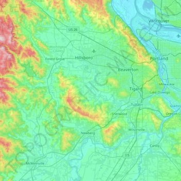
Name: Topografische Karte Tualatin River, Höhe, Relief.
Ort: Tualatin River, Washington County, Oregon, United States (45.33804 -123.40799 45.51229 -122.64732)
Durchschnittliche Höhe: 117 m
Minimale Höhe: -3 m
Maximale Höhe: 740 m
The drainage area of the river is approximately 712 square miles (1,840 km2) with 27 creeks feeding into the Tualatin. Its watershed is 15 percent urbanized, 35 percent agricultural, and 50 percent forested. The river drops 1,800 feet (550 m) in elevation during its first 12 miles (19 km) and then only an additional 250 feet (76 m) for the remaining 71 miles (114 km) of its course. This creates a slow river for the majority of the course, creating problems with pollution. Pollution reached a point that in 1989 local agencies were forced to begin cleaning up the river after the Tualatin failed water quality standards outlined in the Clean Water Act of 1972. It was the first river in the state to fail overall pollution limits.
Andere topografische Karten
Klicken Sie auf eine Karte, um ihre Topografie, ihre Höhe und ihr Relief anzuzeigen.
Hillsboro
United States > Oregon > Washington County
Hillsboro, Washington County, Oregon, United States
Durchschnittliche Höhe: 53 m
Tigard
United States > Oregon > Washington County
Tigard, Washington County, Oregon, United States
Durchschnittliche Höhe: 83 m
Sherwood
United States > Oregon > Washington County
Sherwood, Washington County, Oregon, 97140, United States
Durchschnittliche Höhe: 68 m
Beaverton
United States > Oregon > Washington County
Beaverton, Washington County, Oregon, United States
Durchschnittliche Höhe: 106 m
Forest Grove
United States > Oregon > Washington County
Forest Grove, Washington County, Oregon, 97116, United States
Durchschnittliche Höhe: 61 m
Banks
United States > Oregon > Washington County
Banks, Washington County, Oregon, 97106, United States
Durchschnittliche Höhe: 70 m
North Plains
United States > Oregon > Washington County
North Plains, Washington County, Oregon, United States
Durchschnittliche Höhe: 57 m
Laurelwood
United States > Oregon > Washington County
Laurelwood, Washington County, Oregon, United States
Durchschnittliche Höhe: 165 m
Tualatin
United States > Oregon > Washington County
Tualatin, Washington County, Oregon, 97062, United States
Durchschnittliche Höhe: 70 m
L.L. Stub Stewart State Park
United States > Oregon > Washington County
L.L. Stub Stewart State Park, Service Road, Washington County, Oregon, 97109, United States
Durchschnittliche Höhe: 299 m
Rock Creek
United States > Oregon > Washington County
Rock Creek, Washington County, Oregon, United States
Durchschnittliche Höhe: 65 m
Chehalem
United States > Oregon > Washington County
Chehalem, Washington County, Oregon, 97140, United States
Durchschnittliche Höhe: 181 m
Vose
United States > Oregon > Washington County > Beaverton
Vose, Beaverton, Washington County, Oregon, United States
Durchschnittliche Höhe: 70 m
Denney Whitford/Raleigh West
United States > Oregon > Washington County > Beaverton
Denney Whitford/Raleigh West, Beaverton, Washington County, Oregon, United States
Durchschnittliche Höhe: 72 m
Cornelius
United States > Oregon > Washington County
Cornelius, Washington County, Oregon, United States
Durchschnittliche Höhe: 50 m
King City
United States > Oregon > Washington County
King City, Washington County, Oregon, United States
Durchschnittliche Höhe: 74 m
Timber
United States > Oregon > Washington County
Timber, Washington County, Oregon, 97144, United States
Durchschnittliche Höhe: 319 m
Pendelton Creek
United States > Oregon > Washington County > Portland
Pendelton Creek, Raleigh Hills, Portland, Washington County, Oregon, 97221, United States
Durchschnittliche Höhe: 100 m
Gaston
United States > Oregon > Washington County
Gaston, Washington County, Oregon, United States
Durchschnittliche Höhe: 66 m