
Topografische Karte Beaverton
Interaktive Karte
Klicken Sie auf die Karte, um die Höhe anzuzeigen.
Über diese Karte
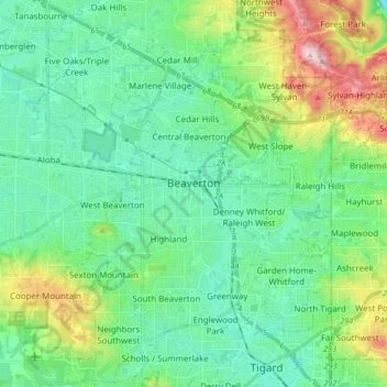
Name: Topografische Karte Beaverton, Höhe, Relief.
Ort: Beaverton, Washington County, Oregon, United States (45.42459 -122.87772 45.54296 -122.74366)
Durchschnittliche Höhe: 106 m
Minimale Höhe: 15 m
Maximale Höhe: 386 m
As of January 2020, Beaverton covers a total area of 19.7 square miles (51 km2), all of it land except for small creeks, ponds, and lakes. The city is located along the eastern edge of the Tualatin Valley just west of the Tualatin Mountains. It is bordered by Portland to the east, Hillsboro to the west, and Tigard to the south. Much of the remaining area surrounding Beaverton in the north and southwest constitutes unincorporated Washington County land. The elevation within city limits ranges from as high as 698.2 feet (212.8 m) above sea level to as low as 131.7 feet (40.1 m) above sea level. The city averages at 189 feet (58 m) above sea level.
Andere topografische Karten
Klicken Sie auf eine Karte, um ihre Topografie, ihre Höhe und ihr Relief anzuzeigen.
Hillsboro
United States > Oregon > Washington County
Hillsboro, Washington County, Oregon, United States
Durchschnittliche Höhe: 53 m
Tigard
United States > Oregon > Washington County
Tigard, Washington County, Oregon, United States
Durchschnittliche Höhe: 83 m
Sherwood
United States > Oregon > Washington County
Sherwood, Washington County, Oregon, 97140, United States
Durchschnittliche Höhe: 68 m
Forest Grove
United States > Oregon > Washington County
Forest Grove, Washington County, Oregon, 97116, United States
Durchschnittliche Höhe: 61 m
Tualatin River
United States > Oregon > Washington County
Tualatin River, Washington County, Oregon, United States
Durchschnittliche Höhe: 117 m
Banks
United States > Oregon > Washington County
Banks, Washington County, Oregon, 97106, United States
Durchschnittliche Höhe: 70 m
North Plains
United States > Oregon > Washington County
North Plains, Washington County, Oregon, United States
Durchschnittliche Höhe: 57 m
Laurelwood
United States > Oregon > Washington County
Laurelwood, Washington County, Oregon, United States
Durchschnittliche Höhe: 165 m
Tualatin
United States > Oregon > Washington County
Tualatin, Washington County, Oregon, 97062, United States
Durchschnittliche Höhe: 70 m
L.L. Stub Stewart State Park
United States > Oregon > Washington County
L.L. Stub Stewart State Park, Service Road, Washington County, Oregon, 97109, United States
Durchschnittliche Höhe: 299 m
Rock Creek
United States > Oregon > Washington County
Rock Creek, Washington County, Oregon, United States
Durchschnittliche Höhe: 65 m
Chehalem
United States > Oregon > Washington County
Chehalem, Washington County, Oregon, 97140, United States
Durchschnittliche Höhe: 181 m
Vose
United States > Oregon > Washington County > Beaverton
Vose, Beaverton, Washington County, Oregon, United States
Durchschnittliche Höhe: 70 m
Denney Whitford/Raleigh West
United States > Oregon > Washington County > Beaverton
Denney Whitford/Raleigh West, Beaverton, Washington County, Oregon, United States
Durchschnittliche Höhe: 72 m
Cornelius
United States > Oregon > Washington County
Cornelius, Washington County, Oregon, United States
Durchschnittliche Höhe: 50 m
King City
United States > Oregon > Washington County
King City, Washington County, Oregon, United States
Durchschnittliche Höhe: 74 m
Timber
United States > Oregon > Washington County
Timber, Washington County, Oregon, 97144, United States
Durchschnittliche Höhe: 319 m
Pendelton Creek
United States > Oregon > Washington County > Portland
Pendelton Creek, Raleigh Hills, Portland, Washington County, Oregon, 97221, United States
Durchschnittliche Höhe: 100 m
Gaston
United States > Oregon > Washington County
Gaston, Washington County, Oregon, United States
Durchschnittliche Höhe: 66 m