
Topografische Karte Gannett Peak
Interaktive Karte
Klicken Sie auf die Karte, um die Höhe anzuzeigen.
Über diese Karte
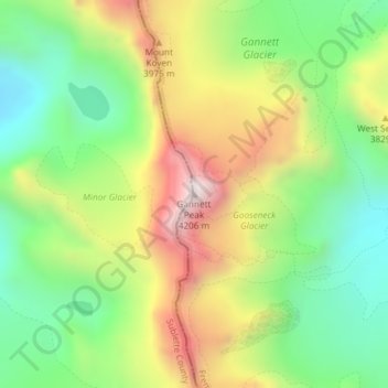
Name: Topografische Karte Gannett Peak, Höhe, Relief.
Ort: Gannett Peak, Fremont County, Wyoming, VS (43.18435 -109.65409 43.18445 -109.65399)
Durchschnittliche Höhe: 3.700 m
Minimale Höhe: 3.335 m
Maximale Höhe: 4.208 m
Andere topografische Karten
Klicken Sie auf eine Karte, um ihre Topografie, ihre Höhe und ihr Relief anzuzeigen.
Yellowstone National Park
Yellowstone National Park, Mary Mountain-Nez Perce, Teton County, Wyoming, VS
Durchschnittliche Höhe: 2.450 m
Rock Springs
VS > Wyoming > Rock Springs
Rock Springs, Sweetwater County, Wyoming, 82901, VS
Durchschnittliche Höhe: 2.011 m
Grand Teton National Park
Grand Teton National Park, Teton Park Road, Teton County, Wyoming, 83013, VS
Durchschnittliche Höhe: 2.409 m