Geolokalisieren

Topografische Karte Grand Teton National Park

Interaktive Karte

Klicken Sie auf die Karte, um die Höhe anzuzeigen.

Über diese Karte

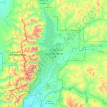
Name: Topografische Karte Grand Teton National Park, Höhe, Relief.

Ort: Grand Teton National Park, Teton Park Road, Teton County, Wyoming, 83013, VS (43.53792 -110.94842 44.08401 -110.42273)

Durchschnittliche Höhe: 2.409 m

Minimale Höhe: 1.893 m

Maximale Höhe: 4.117 m

Andere topografische Karten

Klicken Sie auf eine Karte, um ihre Topografie, ihre Höhe und ihr Relief anzuzeigen.

Yellowstone National Park

VS > Wyoming

Yellowstone National Park, Mary Mountain-Nez Perce, Teton County, Wyoming, VS

Durchschnittliche Höhe: 2.450 m

Rock Springs

VS > Wyoming > Rock Springs

Rock Springs, Sweetwater County, Wyoming, 82901, VS

Durchschnittliche Höhe: 2.011 m

Sweetwater County

VS > Wyoming

Sweetwater County, Wyoming, VS

Durchschnittliche Höhe: 2.142 m

Mount Humphreys

VS > Wyoming

Mount Humphreys, Park County, Wyoming, VS

Durchschnittliche Höhe: 2.970 m

Laramie Peak

VS > Wyoming

Laramie Peak, Albany County, Wyoming, VS

Durchschnittliche Höhe: 2.755 m

Gannett Peak

VS > Wyoming

Gannett Peak, Fremont County, Wyoming, VS

Durchschnittliche Höhe: 3.700 m

Natrona County

VS > Wyoming

Natrona County, Wyoming, VS

Durchschnittliche Höhe: 1.855 m