
Topografische Karte Raon-l'Étape
Interaktive Karte
Klicken Sie auf die Karte, um die Höhe anzuzeigen.
Über diese Karte
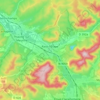
Name: Topografische Karte Raon-l'Étape, Höhe, Relief.
Durchschnittliche Höhe: 362 m
Minimale Höhe: 219 m
Maximale Höhe: 604 m
Raon-l'Étape is positioned at the mouth of the Plaine [fr] at the point where it converges into the Meurthe, itself a tributary of the Moselle. Because it is on departmental frontier with the adjacent Meurthe-et-Moselle département, Raon-l'Étape is sometimes known as the "Gateway to the Vosges" (porte des Vosges). The town is positioned at a point where relatively flat lands transform into a much more mountainous topography: the mountains have for centuries restricted the options for travellers between francophone France and Alsace (formerly the western reaches of the Empire on the other side of the Vosges). The position of Raon has therefore been critical to influencing the movements of merchandise in peace time and of armies in war time for many centuries.
Andere topografische Karten
Klicken Sie auf eine Karte, um ihre Topografie, ihre Höhe und ihr Relief anzuzeigen.
Harchéchamp
Harchéchamp, Neufchâteau, Vosges, Grand Est, Metropolitan France, 88300, France
Durchschnittliche Höhe: 348 m
Blevaincourt
Blevaincourt, Neufchâteau, Vosges, Grand Est, Metropolitan France, 88320, France
Durchschnittliche Höhe: 361 m
Le Chêne
France > Grand Est > Vosges > Rupt-sur-Moselle
Le Chêne, Rupt-sur-Moselle, Épinal, Vosges, Grand Est, Metropolitan France, 88360, France
Durchschnittliche Höhe: 576 m
Mont-lès-Neufchâteau
Mont-lès-Neufchâteau, Neufchâteau, Vosges, Grand Est, Metropolitan France, 88300, France
Durchschnittliche Höhe: 341 m
La Mergerie
France > Grand Est > Vosges > Chef-Haut
La Mergerie, Chef-Haut, Épinal, Vosges, Grand Est, Metropolitan France, 88500, France
Durchschnittliche Höhe: 360 m
Le Thillot
Le Thillot, Épinal, Vosges, Grand Est, Metropolitan France, 88160, France
Durchschnittliche Höhe: 623 m
Neufchâteau
Neufchâteau, Vosges, Grand Est, Metropolitan France, 88300, France
Durchschnittliche Höhe: 334 m
Nayemont
France > Grand Est > Vosges > Ban-de-Sapt
Nayemont, Ban-de-Sapt, Saint-Dié-des-Vosges, Vosges, Grand Est, Metropolitan France, 88210, France
Durchschnittliche Höhe: 604 m
La Croix Ferry
France > Grand Est > Vosges > Le Tholy > Le Rain Brice
La Croix Ferry, Le Rain Brice, Le Tholy, Saint-Dié-des-Vosges, Vosges, Grand Est, Metropolitan France, 88530, France
Durchschnittliche Höhe: 659 m
Rupt-sur-Moselle
France > Grand Est > Vosges > Rupt-sur-Moselle
Rupt-sur-Moselle, Épinal, Vosges, Grand Est, Metropolitan France, 88360, France
Durchschnittliche Höhe: 637 m
Plombières-les-Bains
Plombières-les-Bains, Épinal, Vosges, Grand Est, Metropolitan France, 88370, France
Durchschnittliche Höhe: 516 m
Colroy-la-Grande
France > Grand Est > Vosges > Provenchères-et-Colroy
Colroy-la-Grande, Provenchères-et-Colroy, Saint-Dié-des-Vosges, Vosges, Grand Est, Metropolitan France, 88490, France
Durchschnittliche Höhe: 516 m
Les Poulières
France > Grand Est > Vosges > Les Poulières
Les Poulières, Saint-Dié-des-Vosges, Vosges, Grand Est, Metropolitan France, 88600, France
Durchschnittliche Höhe: 510 m
Bettegney-Saint-Brice
France > Grand Est > Vosges > Bettegney-Saint-Brice
Bettegney-Saint-Brice, Épinal, Vosges, Grand Est, Metropolitan France, 88450, France
Durchschnittliche Höhe: 349 m
Laveline-devant-Bruyères
France > Grand Est > Vosges > Laveline-devant-Bruyères
Laveline-devant-Bruyères, Épinal, Vosges, Grand Est, Metropolitan France, 88600, France
Durchschnittliche Höhe: 492 m
Saint-Maurice-sur-Moselle
France > Grand Est > Vosges > Saint-Maurice-sur-Moselle
Saint-Maurice-sur-Moselle, Épinal, Vosges, Grand Est, Metropolitan France, 88560, France
Durchschnittliche Höhe: 815 m
Plainfaing
Plainfaing, Saint-Dié-des-Vosges, Vosges, Grand Est, Metropolitan France, 88230, France
Durchschnittliche Höhe: 815 m
Basse-sur-le-Rupt
France > Grand Est > Vosges > Basse-sur-le-Rupt
Basse-sur-le-Rupt, Saint-Dié-des-Vosges, Vosges, Grand Est, Metropolitan France, 88120, France
Durchschnittliche Höhe: 677 m
Schlitte Mountain
France > Grand Est > Vosges > La Bresse
Schlitte Mountain, Route de Vologne, La Bresse, Saint-Dié-des-Vosges, Vosges, Grand Est, Metropolitan France, 88250, France
Durchschnittliche Höhe: 1.032 m
Ollainville
Ollainville, Neufchâteau, Vosges, Grand Est, Metropolitan France, 88170, France
Durchschnittliche Höhe: 354 m
Bellefontaine
Bellefontaine, Épinal, Vosges, Grand Est, Metropolitan France, 88370, France
Durchschnittliche Höhe: 544 m