
Topografische Karte Les Poulières
Interaktive Karte
Klicken Sie auf die Karte, um die Höhe anzuzeigen.
Über diese Karte
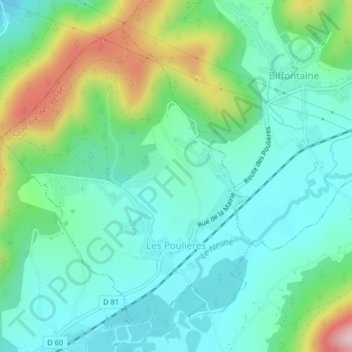
Name: Topografische Karte Les Poulières, Höhe, Relief.
Durchschnittliche Höhe: 510 m
Minimale Höhe: 438 m
Maximale Höhe: 709 m
The commune is positioned between Épinal to the west and Saint-Dié to the north-east, in the valley of the Neuné, a tributary of the Vologne River. Neighbouring communes are Biffontaine and La Chapelle-devant-Bruyères. Les Poulières is at the confluence of several roads, but roads here are small and twisting, thanks to the topography, on the western fringes of the Vosges Mountains.