
Spenden
Rüsten Sie sich für Ihr nächstes Abenteuer:
Als Amazon-Partner erhält diese Website eine Provision für qualifizierte Käufe, ohne zusätzliche Kosten für Sie.
Topografische Karte McDonalds
Klicken Sie auf die Karte, um die Höhe anzuzeigen.
Spenden
Rüsten Sie sich für Ihr nächstes Abenteuer:
Als Amazon-Partner erhält diese Website eine Provision für qualifizierte Käufe, ohne zusätzliche Kosten für Sie.
Über diese Karte
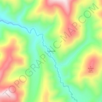
Name: Topografische Karte McDonalds, Höhe, Relief.
Ort: McDonalds, Shoshone County, Idaho, United States (47.01436 -115.17236 47.05436 -115.13236)
Durchschnittliche Höhe: 1.692 m
Minimale Höhe: 1.473 m
Maximale Höhe: 1.971 m
Spenden
Rüsten Sie sich für Ihr nächstes Abenteuer:
Als Amazon-Partner erhält diese Website eine Provision für qualifizierte Käufe, ohne zusätzliche Kosten für Sie.
Andere topografische Karten
Klicken Sie auf eine Karte, um ihre Topografie, ihre Höhe und ihr Relief anzuzeigen.
Wardner
United States > Idaho > Shoshone County
Wardner is located at 47°31′23″N 116°8′3″W / 47.52306°N 116.13417°W / 47.52306; -116.13417 (47.523164, -116.134190), at an elevation of 2,657 feet (810 m) above sea level.
Durchschnittliche Höhe: 1.186 m
Kellogg
United States > Idaho > Shoshone County
Kellogg is located at 47°32′18″N 116°07′31″W / 47.53833°N 116.12528°W / 47.53833; -116.12528 (47.538391, -116.125406), at an elevation of 2,303 feet (702 m) above sea level.
Durchschnittliche Höhe: 939 m
Mullan
United States > Idaho > Shoshone County
In Shoshone County at the east end of the Silver Valley, Mullan is in a sheltered canyon of the Coeur d'Alene Mountains at an elevation of 3,278 feet (1,000 m) above sea level. The entrance to the Lucky Friday mine is several hundred yards east of the city center; the active mine (silver, lead, & zinc)…
Durchschnittliche Höhe: 1.168 m
Spenden
Rüsten Sie sich für Ihr nächstes Abenteuer:
Als Amazon-Partner erhält diese Website eine Provision für qualifizierte Käufe, ohne zusätzliche Kosten für Sie.
Mullan
United States > Idaho > Shoshone County
In Shoshone County at the east end of the Silver Valley, Mullan is in a sheltered canyon of the Coeur d'Alene Mountains at an elevation of 3,278 feet (1,000 m) above sea level. The entrance to the Lucky Friday mine is several hundred yards east of the city center; the active mine (silver, lead, & zinc)…
Durchschnittliche Höhe: 1.168 m
Kellogg
United States > Idaho > Shoshone County
Kellogg is located at 47°32′18″N 116°07′31″W / 47.53833°N 116.12528°W / 47.53833; -116.12528 (47.538391, -116.125406), at an elevation of 2,303 feet (702 m) above sea level.
Durchschnittliche Höhe: 939 m
Spenden
Rüsten Sie sich für Ihr nächstes Abenteuer:
Als Amazon-Partner erhält diese Website eine Provision für qualifizierte Käufe, ohne zusätzliche Kosten für Sie.