
Spenden
Rüsten Sie sich für Ihr nächstes Abenteuer:
Als Amazon-Partner erhält diese Website eine Provision für qualifizierte Käufe, ohne zusätzliche Kosten für Sie.
Topografische Karte Kellogg
Klicken Sie auf die Karte, um die Höhe anzuzeigen.
Spenden
Rüsten Sie sich für Ihr nächstes Abenteuer:
Als Amazon-Partner erhält diese Website eine Provision für qualifizierte Käufe, ohne zusätzliche Kosten für Sie.
Kellogg
Kellogg is located at 47°32′18″N 116°07′31″W / 47.53833°N 116.12528°W / 47.53833; -116.12528 (47.538391, -116.125406), at an elevation of 2,303 feet (702 m) above sea level.
Spenden
Rüsten Sie sich für Ihr nächstes Abenteuer:
Als Amazon-Partner erhält diese Website eine Provision für qualifizierte Käufe, ohne zusätzliche Kosten für Sie.
Über diese Karte
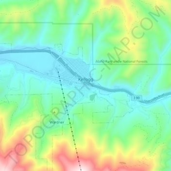
Name: Topografische Karte Kellogg, Höhe, Relief.
Ort: Kellogg, Shoshone County, Idaho, 83837, United States (47.52081 -116.18408 47.55095 -116.09384)
Durchschnittliche Höhe: 939 m
Minimale Höhe: 682 m
Maximale Höhe: 1.596 m
Spenden
Rüsten Sie sich für Ihr nächstes Abenteuer:
Als Amazon-Partner erhält diese Website eine Provision für qualifizierte Käufe, ohne zusätzliche Kosten für Sie.
Andere topografische Karten
Klicken Sie auf eine Karte, um ihre Topografie, ihre Höhe und ihr Relief anzuzeigen.
Burke
United States > Idaho > Shoshone County > Mace
Burke is located about 7 miles (11 km) northeast of Wallace, at an elevation of 3,700 feet (1,130 m) above sea level. It is accessed from Wallace on Burke-Canyon Creek Road (State Highway 4). The town is located approximately 100 miles (160 km) south of the Canadian province of British Columbia, and roughly 5…
Durchschnittliche Höhe: 1.459 m
Spenden
Rüsten Sie sich für Ihr nächstes Abenteuer:
Als Amazon-Partner erhält diese Website eine Provision für qualifizierte Käufe, ohne zusätzliche Kosten für Sie.
Spenden
Rüsten Sie sich für Ihr nächstes Abenteuer:
Als Amazon-Partner erhält diese Website eine Provision für qualifizierte Käufe, ohne zusätzliche Kosten für Sie.
Spenden
Rüsten Sie sich für Ihr nächstes Abenteuer:
Als Amazon-Partner erhält diese Website eine Provision für qualifizierte Käufe, ohne zusätzliche Kosten für Sie.