Topografische Karte County Carlow
Interaktive Karte
Klicken Sie auf die Karte, um die Höhe anzuzeigen.
Über diese Karte
![Topografische Karte County Carlow, Höhe, Relief](/pub/maps/relation/kff3/sg1m2/thumbnail.jpg)
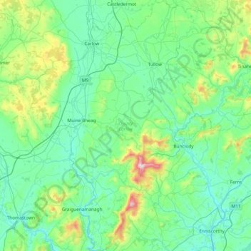
Name: Topografische Karte County Carlow, Höhe, Relief.
Ort: County Carlow, Leinster, Irland (52.46359 -7.10794 52.91802 -6.50494)
Durchschnittliche Höhe: 126 m
Minimale Höhe: 0 m
Maximale Höhe: 789 m
Andere topografische Karten
Klicken Sie auf eine Karte, um ihre Topografie, ihre Höhe und ihr Relief anzuzeigen.
![Topografische Karte Cliffs of Moher, Höhe, Relief](/pub/maps/way/zn5k/jk2wktf/icon.jpg)
Cliffs of Moher
Cliffs of Moher, Ballysteen ED, West Clare Municipal District, County Clare, Munster, Irland
Durchschnittliche Höhe: 55 m
![Topografische Karte Carrickmacross-Castleblaney Municipal District, Höhe, Relief](/pub/maps/relation/fq18/w8b1zs/icon.jpg)
Carrickmacross-Castleblaney Municipal District
Carrickmacross-Castleblaney Municipal District, County Monaghan, Ulster, Irland
Durchschnittliche Höhe: 114 m
![Topografische Karte Killaloe Municipal District, Höhe, Relief](/pub/maps/relation/dv3l/2gbm57/icon.jpg)
Killaloe Municipal District
Killaloe Municipal District, County Clare, Munster, Irland
Durchschnittliche Höhe: 85 m
![Topografische Karte Lear, Höhe, Relief](/pub/maps/relation/55kl/5zgrkl/icon.jpg)
Lear
Lear, Canningstown ED, Bailieborough-Cootehill Municipal District, County Cavan, Ulster, Irland
Durchschnittliche Höhe: 189 m
![Topografische Karte Dunmore East, Höhe, Relief](/pub/maps/relation/kk9m/htfnt6/icon.jpg)
Dunmore East
Dunmore East, County Waterford, Munster, X91 C677, Irland
Durchschnittliche Höhe: 36 m
![Topografische Karte Knockanteedan, Höhe, Relief](/pub/maps/node/pttj/37k64bz4/icon.jpg)
Knockanteedan
Knockanteedan, Glassamucky, Bohernabreena DED 1986, South Dublin, County Dublin, Leinster, D24 T651, Irland
Durchschnittliche Höhe: 243 m
![Topografische Karte Cloncarney, Höhe, Relief](/pub/maps/relation/d1gp/w8bdtf/icon.jpg)
Cloncarney
Irland > County Donegal > Letterkenny Municipal District
Cloncarney, Templedouglas ED, Letterkenny Municipal District, County Donegal, Irland
Durchschnittliche Höhe: 123 m
![Topografische Karte Little Sugar Loaf, Höhe, Relief](/pub/maps/node/27nx/fb69b8zs/icon.jpg)
Little Sugar Loaf
Little Sugar Loaf, The Municipal District of Bray, County Wicklow, Leinster, A63 FX34, Irland
Durchschnittliche Höhe: 131 m
![Topografische Karte Ballykeeran, Höhe, Relief](/pub/maps/node/gm3l/29m3kwkl/icon.jpg)
Ballykeeran
Ballykeeran, The Municipal District of Athlone — Moate, County Westmeath, Leinster, N37 VK74, Irland
Durchschnittliche Höhe: 47 m
![Topografische Karte Ballymahon, Höhe, Relief](/pub/maps/relation/t5tj/xdqwtf/icon.jpg)
Ballymahon
Ballymahon, Castlerickard ED, The Municipal District of Trim, County Meath, Leinster, Irland
Durchschnittliche Höhe: 66 m
![Topografische Karte Glencolumbkille, Höhe, Relief](/pub/maps/relation/c3l/vbqjcz/icon.jpg)
Glencolumbkille
Glencolumbkille, County Donegal, Ulster, Irland
Durchschnittliche Höhe: 95 m
![Topografische Karte Glenties Municipal District, Höhe, Relief](/pub/maps/relation/pxm2/94gvs8/icon.jpg)
Glenties Municipal District
Glenties Municipal District, County Donegal, Ulster, Irland
Durchschnittliche Höhe: 90 m
![Topografische Karte Ennis Municipal District, Höhe, Relief](/pub/maps/relation/4pgt/xsfmnh/icon.jpg)
Ennis Municipal District
Ennis Municipal District, County Clare, Munster, Irland
Durchschnittliche Höhe: 39 m
![Topografische Karte Swanlinbar, Höhe, Relief](/pub/maps/node/7v1h/8bv8rz4/icon.jpg)
Swanlinbar
Swanlinbar, Cavan-Belturbet Municipal District, County Cavan, Irland
Durchschnittliche Höhe: 97 m
![Topografische Karte Gubnafarna, Höhe, Relief](/pub/maps/relation/bdn/xmh1kl/icon.jpg)
Gubnafarna
Gubnafarna, Kinawley ED, Cavan-Belturbet Municipal District, County Cavan, Irland
Durchschnittliche Höhe: 178 m
![Topografische Karte The Municipal District of Muinebeag, Höhe, Relief](/pub/maps/relation/1znx/9dsx18/icon.jpg)
The Municipal District of Muinebeag
The Municipal District of Muinebeag, County Carlow, Leinster, Irland
Durchschnittliche Höhe: 129 m
![Topografische Karte Naas, Höhe, Relief](/pub/maps/relation/d3dn/xdk65k/icon.jpg)
Naas
Naas, The Municipal District of Naas, County Kildare, Leinster, Irland
Durchschnittliche Höhe: 99 m
![Topografische Karte Goatstown, Höhe, Relief](/pub/maps/node/lw14/sw6z27s8/icon.jpg)
Goatstown
Goatstown, Dún Laoghaire-Rathdown, County Dublin, Leinster, D14 WR83, Irland
Durchschnittliche Höhe: 57 m
![Topografische Karte Derrycastle, Höhe, Relief](/pub/maps/relation/qvt6/6btwnh/icon.jpg)
Derrycastle
Derrycastle, The Municipal District of Nenagh, County Tipperary, Munster, Irland
Durchschnittliche Höhe: 152 m
![Topografische Karte The Municipal District of Nenagh, Höhe, Relief](/pub/maps/relation/75f3/mx1drr/icon.jpg)
The Municipal District of Nenagh
The Municipal District of Nenagh, County Tipperary, Munster, Irland
Durchschnittliche Höhe: 116 m
![Topografische Karte Ballybay-Clones Municipal District, Höhe, Relief](/pub/maps/relation/thcz/j63jzs/icon.jpg)
Ballybay-Clones Municipal District
Ballybay-Clones Municipal District, County Monaghan, Ulster, Irland
Durchschnittliche Höhe: 114 m
![Topografische Karte Glenmore, Höhe, Relief](/pub/maps/relation/vhtj/vhnntj/icon.jpg)
Glenmore
Glenmore, Rathcor ED, The Municipal District of Dundalk, County Louth, Leinster, Irland
Durchschnittliche Höhe: 241 m
![Topografische Karte The Municipal District of Gorey — Kilmuckridge, Höhe, Relief](/pub/maps/relation/fkgp/qxdfkl/icon.jpg)
The Municipal District of Gorey — Kilmuckridge
The Municipal District of Gorey — Kilmuckridge, County Wexford, Leinster, Irland
Durchschnittliche Höhe: 58 m
![Topografische Karte Curraheen, Höhe, Relief](/pub/maps/relation/4k3q/d1fxnh/icon.jpg)
Curraheen
Curraheen, Glanbehy ED, Kenmare Municipal District, County Kerry, Munster, Irland
Durchschnittliche Höhe: 124 m
![Topografische Karte Balliny South, Höhe, Relief](/pub/maps/relation/pscz/9jl83l/icon.jpg)
Balliny South
Balliny South, Derreen ED, West Clare Municipal District, County Clare, Munster, Irland
Durchschnittliche Höhe: 253 m
![Topografische Karte Kenmare Municipal District, Höhe, Relief](/pub/maps/relation/6tf/xsbh1h/icon.jpg)
Kenmare Municipal District
Kenmare Municipal District, County Kerry, Munster, Irland
Durchschnittliche Höhe: 98 m
![Topografische Karte The Municipal District of Baltinglass, Höhe, Relief](/pub/maps/relation/6dtf/bmq3tf/icon.jpg)
The Municipal District of Baltinglass
The Municipal District of Baltinglass, County Wicklow, Leinster, Irland
Durchschnittliche Höhe: 182 m
![Topografische Karte Ballynabarney, Höhe, Relief](/pub/maps/relation/6d9m/lqfvs8/icon.jpg)
Ballynabarney
Ballynabarney, Wingfield ED, The Municipal District of Gorey — Kilmuckridge, County Wexford, Leinster, Irland
Durchschnittliche Höhe: 241 m
![Topografische Karte An Coimín Theas, Höhe, Relief](/pub/maps/relation/f414/dmtw9m/icon.jpg)
An Coimín Theas
An Coimín Theas, Toghroinn ceantair Dún Chaoin, Kenmare Municipal District, County Kerry, Munster, Irland
Durchschnittliche Höhe: 248 m
![Topografische Karte Abbeyfeale, Höhe, Relief](/pub/maps/relation/nwtj/pq313q/icon.jpg)
Abbeyfeale
Irland > County Limerick > The Municipal District of Newcastle West
Abbeyfeale, The Municipal District of Newcastle West, County Limerick, Munster, Irland
Durchschnittliche Höhe: 150 m
![Topografische Karte The Municipal District of Kanturk – Mallow, Höhe, Relief](/pub/maps/relation/w6t6/xfrknh/icon.jpg)
The Municipal District of Kanturk – Mallow
The Municipal District of Kanturk – Mallow, County Cork, Munster, Irland
Durchschnittliche Höhe: 182 m
![Topografische Karte Slieve League, Höhe, Relief](/pub/maps/node/6w3l/z648gb3/icon.jpg)
Slieve League
Slieve League, Donegal Municipal District, County Donegal, Irland
Durchschnittliche Höhe: 233 m
![Topografische Karte Bridgetown, Höhe, Relief](/pub/maps/relation/vqtj/7m5xs8/icon.jpg)
Bridgetown
Bridgetown, Clonea, The Municipal District of Comeragh, County Waterford, Munster, Irland
Durchschnittliche Höhe: 89 m
![Topografische Karte Tuam Municipal District, Höhe, Relief](/pub/maps/relation/4zmt/wsw414/icon.jpg)
Tuam Municipal District
Tuam Municipal District, County Galway, Connacht, Irland
Durchschnittliche Höhe: 54 m
![Topografische Karte Arless ED, Höhe, Relief](/pub/maps/relation/48gt/l5ppnh/icon.jpg)
Arless ED
Arless ED, The Municipal District of Graiguecullen — Portarlington, County Laois, Leinster, Irland
Durchschnittliche Höhe: 97 m
![Topografische Karte Tullagreen, Höhe, Relief](/pub/maps/relation/mcnh/sbnzdn/icon.jpg)
Tullagreen
Irland > County Cork > Municipal District of Cobh
Tullagreen, Carrigtohill ED, Municipal District of Cobh, County Cork, Munster, Irland
Durchschnittliche Höhe: 12 m
![Topografische Karte Loughrea Municipal District, Höhe, Relief](/pub/maps/relation/trcz/zk2btf/icon.jpg)
Loughrea Municipal District
Loughrea Municipal District, County Galway, Connacht, Irland
Durchschnittliche Höhe: 69 m
![Topografische Karte The Municipal District of Navan, Höhe, Relief](/pub/maps/relation/djf3/6tkbnh/icon.jpg)
The Municipal District of Navan
The Municipal District of Navan, County Meath, Leinster, Irland
Durchschnittliche Höhe: 62 m
![Topografische Karte Brandon Hill, Höhe, Relief](/pub/maps/node/ljs8/g3vtbgp/icon.jpg)
Brandon Hill
Brandon Hill, The Municipal District of Callan — Thomastown, County Kilkenny, Leinster, R95 EKN5, Irland
Durchschnittliche Höhe: 294 m
![Topografische Karte Garvagh/Arigna ED, Höhe, Relief](/pub/maps/relation/8znh/tbr5cz/icon.jpg)
Garvagh/Arigna ED
Garvagh/Arigna ED, Manorhamilton Municipal District, County Leitrim, Connacht, Irland
Durchschnittliche Höhe: 201 m