
Topografische Karte Slieve League
Interaktive Karte
Klicken Sie auf die Karte, um die Höhe anzuzeigen.
Über diese Karte
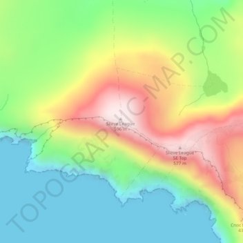
Name: Topografische Karte Slieve League, Höhe, Relief.
Durchschnittliche Höhe: 233 m
Minimale Höhe: -5 m
Maximale Höhe: 595 m
Andere topografische Karten
Klicken Sie auf eine Karte, um ihre Topografie, ihre Höhe und ihr Relief anzuzeigen.
Glencolumbkille
Es ist eine etwa zwei Meter tiefe Röhre, die aber aufgrund fehlender Tritt- und Haltemöglichkeiten nicht benutzt werden kann. Von der früheren Erforschung ist bekannt, dass die Röhre neben einem rechteckigen, über sechs Meter langen, etwa 2,5 Meter breiten und 1,6 m hohen Raum endet, in den man durch…
Durchschnittliche Höhe: 95 m