
Topografische Karte Glenties Municipal District
Interaktive Karte
Klicken Sie auf die Karte, um die Höhe anzuzeigen.
Über diese Karte
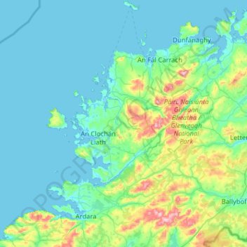
Name: Topografische Karte Glenties Municipal District, Höhe, Relief.
Ort: Glenties Municipal District, County Donegal, Ulster, Irland (54.68883 -8.62103 55.27605 -7.83491)
Durchschnittliche Höhe: 90 m
Minimale Höhe: -2 m
Maximale Höhe: 724 m
Andere topografische Karten
Klicken Sie auf eine Karte, um ihre Topografie, ihre Höhe und ihr Relief anzuzeigen.
Cloncarney
Irland > County Donegal > Letterkenny Municipal District
Cloncarney, Templedouglas ED, Letterkenny Municipal District, County Donegal, Irland
Durchschnittliche Höhe: 123 m
Glencolumbkille
Glencolumbkille, County Donegal, Ulster, Irland
Durchschnittliche Höhe: 95 m
Slieve League
Slieve League, Donegal Municipal District, County Donegal, Irland
Durchschnittliche Höhe: 233 m