
Topografische Karte Ross Behy
Interaktive Karte
Klicken Sie auf die Karte, um die Höhe anzuzeigen.
Über diese Karte
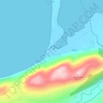
Name: Topografische Karte Ross Behy, Höhe, Relief.
Durchschnittliche Höhe: 57 m
Minimale Höhe: -3 m
Maximale Höhe: 269 m
Andere topografische Karten
Klicken Sie auf eine Karte, um ihre Topografie, ihre Höhe und ihr Relief anzuzeigen.
Curraheen
Curraheen, Glanbehy ED, Kenmare Municipal District, County Kerry, Munster, Irland
Durchschnittliche Höhe: 124 m
Kenmare Municipal District
Kenmare Municipal District, County Kerry, Munster, Irland
Durchschnittliche Höhe: 98 m
An Coimín Theas
An Coimín Theas, Toghroinn ceantair Dún Chaoin, Kenmare Municipal District, County Kerry, Munster, Irland
Durchschnittliche Höhe: 248 m
Valentia
Valentia, Kenmare Municipal District, County Kerry, Munster, Irland
Durchschnittliche Höhe: 39 m