Geolokalisieren

Topografische Karte Kenmare Municipal District

Interaktive Karte

Klicken Sie auf die Karte, um die Höhe anzuzeigen.

Über diese Karte

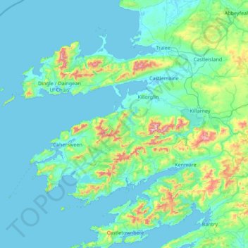
Name: Topografische Karte Kenmare Municipal District, Höhe, Relief.

Ort: Kenmare Municipal District, County Kerry, Munster, Irland (51.68820 -10.61844 52.33778 -9.27401)

Durchschnittliche Höhe: 98 m

Minimale Höhe: -3 m

Maximale Höhe: 1.001 m

Andere topografische Karten

Klicken Sie auf eine Karte, um ihre Topografie, ihre Höhe und ihr Relief anzuzeigen.

Curraheen

Irland > County Kerry

Curraheen, Glanbehy ED, Kenmare Municipal District, County Kerry, Munster, Irland

Durchschnittliche Höhe: 124 m

An Coimín Theas

Irland > County Kerry

An Coimín Theas, Toghroinn ceantair Dún Chaoin, Kenmare Municipal District, County Kerry, Munster, Irland

Durchschnittliche Höhe: 248 m

Valentia

Irland > County Kerry

Valentia, Kenmare Municipal District, County Kerry, Munster, Irland

Durchschnittliche Höhe: 39 m

Ross Behy

Irland > County Kerry

Ross Behy, Glanbehy ED, Kenmare Municipal District, County Kerry, Munster, V93 H5W9, Irland

Durchschnittliche Höhe: 57 m