
Topografische Karte Córdoba
Interaktive Karte
Klicken Sie auf die Karte, um die Höhe anzuzeigen.
Über diese Karte
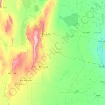
Name: Topografische Karte Córdoba, Höhe, Relief.
Ort: Córdoba, Argentina (-35.01537 -65.77133 -29.50043 -61.77160)
Durchschnittliche Höhe: 324 m
Minimale Höhe: 3 m
Maximale Höhe: 2.660 m
Córdoba, located just north of the geographical center of the nation, is Argentina's fifth-largest province. The main feature of the province is the presence of an extensive plain covering the eastern two-thirds of the province and the existence of three major mountain ranges, which, combined, are known as Sierras de Córdoba: the easternmost range starts just west of the city of Córdoba and reaches altitudes of mostly around 1,000 meters (3,300 feet) in the southern portion and over 1,500 meters (4,900 feet) further north, with a maximum altitude of 1,950 meters (6,400 feet) at Cerro Uritorco. West of this chain, two valleys contain most of the tourist spots in the province: the Calamuchita valley in the south and the Punilla Valley in the north, home of scenic towns such as Villa Carlos Paz, Cosquín, La Cumbre, and La Falda.
Andere topografische Karten
Klicken Sie auf eine Karte, um ihre Topografie, ihre Höhe und ihr Relief anzuzeigen.
Alta Gracia
Argentina > Córdoba > Pedanía Alta Gracia
Alta Gracia, Municipio de Alta Gracia, Pedanía Alta Gracia, Departamento Santa María, Córdoba, X5186, Argentina
Durchschnittliche Höhe: 665 m
Villa Traful
Villa Traful, Comisión de Fomento de Villa Traful, Departamento Los Lagos, Neuquén Province, Q8403, Argentina
Durchschnittliche Höhe: 921 m
San Juan
Argentina > Entre Ríos Province > Distrito Suburbios > Concordia
San Juan, Concordia, Distrito Suburbios, Departamento Concordia, Entre Ríos Province, Argentina
Durchschnittliche Höhe: 41 m
San Antonio de Areco
San Antonio de Areco, Partido de San Antonio de Areco, Buenos Aires, Argentina
Durchschnittliche Höhe: 31 m
Pilar
Pilar, Partido del Pilar, Buenos Aires, Argentina
Durchschnittliche Höhe: 19 m
Paraná
Argentina > Entre Ríos Province > Distrito Sauce
Paraná, Municipio de Paraná, Distrito Sauce, Departamento Paraná, Entre Ríos Province, Argentina
Durchschnittliche Höhe: 38 m
Distrito Villa Antigua
Distrito Villa Antigua, Departamento La Paz, Mendoza, M5590, Argentina
Durchschnittliche Höhe: 512 m
Distrito Ciudad de Malargüe
Distrito Ciudad de Malargüe, Departamento Malargüe, Mendoza, Argentina
Durchschnittliche Höhe: 2.010 m
Bernal
Bernal, Partido de Quilmes, Buenos Aires, Argentina
Durchschnittliche Höhe: 10 m
Isla del Rey
Argentina > Santa Cruz Province
Isla del Rey, Deseado, Santa Cruz Province, Argentina
Durchschnittliche Höhe: 8 m
Varvarco
Argentina > Neuquén Province > Varvarco
Varvarco, Comisión de Fomento de Varvarco - Invernada Vieja, Departamento Minas, Neuquén Province, Argentina
Durchschnittliche Höhe: 1.318 m
Costa Brava
Costa Brava, Partido de Suipacha, Buenos Aires, Argentina
Durchschnittliche Höhe: 47 m
Las Ovejas
Argentina > Neuquén Province > Las Ovejas
Las Ovejas, Municipio de Las Ovejas, Departamento Minas, Neuquén Province, Q8355, Argentina
Durchschnittliche Höhe: 1.292 m
Costa Verde
Argentina > Buenos Aires > Junín
Costa Verde, Junín, Partido de Junín, Buenos Aires, Argentina
Durchschnittliche Höhe: 78 m
Centenario
Argentina > Neuquén Province > Centenario
Centenario, Municipio de Centenario, Departamento Confluencia, Neuquén Province, Argentina
Durchschnittliche Höhe: 308 m
Ifrán
Argentina > Corrientes > Municipio de Yatay Tí Calle > Ifrán
Ifrán, Municipio de Yatay Tí Calle, Departamento Lavalle, Corrientes, W3453XAF, Argentina
Durchschnittliche Höhe: 66 m
Laguna San Rafael
Argentina > Tierra del Fuego Province
Laguna San Rafael, Departamento Ushuaia, Tierra del Fuego Province, Argentina
Durchschnittliche Höhe: 614 m
Valdes Peninsula
Valdes Peninsula, Chubut, SIN DATO, Argentina
Durchschnittliche Höhe: 28 m
Buenos Aires
Argentina > Autonomous City of Buenos Aires
Buenos Aires, Comuna 6, Autonomous City of Buenos Aires, Argentina
Durchschnittliche Höhe: 15 m
Villa La Angostura
Argentina > Neuquén Province > Villa La Angostura
Villa La Angostura, Departamento Los Lagos, Neuquén Province, Argentina
Durchschnittliche Höhe: 928 m
Isla Oyarvide
Isla Oyarvide, Partido de San Fernando, Buenos Aires, Argentina
Durchschnittliche Höhe: 1 m
San Carlos de Bariloche
Argentina > Río Negro Province > San Carlos de Bariloche
San Carlos de Bariloche, Municipio de San Carlos de Bariloche, Departamento Bariloche, Río Negro Province, 8400, Argentina
Durchschnittliche Höhe: 1.042 m
San Isidro
Argentina > Buenos Aires > San Isidro
San Isidro, Partido de San Isidro, Buenos Aires, Argentina
Durchschnittliche Höhe: 17 m
Federal
Argentina > Entre Ríos Province > Federal
Federal, Distrito Francisco Ramírez, Departamento Federal, Entre Ríos Province, Argentina
Durchschnittliche Höhe: 66 m
Río de Las Pavas (Arroyo Maderas)
Río de Las Pavas (Arroyo Maderas), Municipio de El Carmen, Departamento El Carmen, Jujuy, 4603, Argentina
Durchschnittliche Höhe: 1.126 m
Rafael Castillo
Argentina > Buenos Aires > Rafael Castillo
Rafael Castillo, Partido de La Matanza, Buenos Aires, 1755, Argentina
Durchschnittliche Höhe: 26 m
Villa Allende
Argentina > Córdoba > Villa Allende
Villa Allende, Municipio de Villa Allende, Departamento Colón, Córdoba, X5111, Argentina
Durchschnittliche Höhe: 541 m
Tornquist
Argentina > Buenos Aires > Tornquist
Tornquist, Partido de Tornquist, Buenos Aires, Argentina
Durchschnittliche Höhe: 293 m
Autonomous City of Buenos Aires
Autonomous City of Buenos Aires, Argentina
Durchschnittliche Höhe: 15 m
Islas Solis
Islas Solis, Partido de San Fernando, Buenos Aires, Argentina
Durchschnittliche Höhe: 0 m
Banfield
Argentina > Buenos Aires > Banfield
Banfield, Partido de Lomas de Zamora, Buenos Aires, 1828, Argentina
Durchschnittliche Höhe: 14 m
Sierra de la Ventana
Argentina > Buenos Aires > Sierra de la Ventana > Sierra de la Ventana
Sierra de la Ventana, Partido de Tornquist, Buenos Aires, 8168, Argentina
Durchschnittliche Höhe: 272 m
Palermo
Argentina > Buenos Aires > Tandil
Palermo, Tandil, Partido de Tandil, Buenos Aires, Argentina
Durchschnittliche Höhe: 185 m
Pigüé
Argentina > Buenos Aires > Pigüé
Pigüé, Partido de Saavedra, Buenos Aires, Argentina
Durchschnittliche Höhe: 302 m
Pedanía Castaño
Pedanía Castaño, Departamento Río Primero, Córdoba, X5127, Argentina
Durchschnittliche Höhe: 99 m
Río Gallegos
Argentina > Santa Cruz Province, Argentina > Río Gallegos
Río Gallegos, Municipio de Río Gallegos, Güer Aike, Santa Cruz Province, Argentina, Argentina
Durchschnittliche Höhe: 9 m
Resistencia
Argentina > Chaco > Resistencia
Resistencia, Municipio de Resistencia, Departamento San Fernando, Chaco, Argentina
Durchschnittliche Höhe: 51 m
Gualeguaychu
Argentina > Entre Ríos Province > Gualeguaychu
Gualeguaychu, Gualeguaychú, Distrito Costa Uruguay Sur, Departamento Gualeguaychú, Entre Ríos Province, 2820, Argentina
Durchschnittliche Höhe: 19 m
Ramos Mejía
Argentina > Buenos Aires > Ramos Mejía
Ramos Mejía, Partido de La Matanza, Buenos Aires, 1704, Argentina
Durchschnittliche Höhe: 18 m
Ranelagh
Argentina > Buenos Aires > Ranelagh
Ranelagh, Partido de Berazategui, Buenos Aires, Argentina
Durchschnittliche Höhe: 16 m
San Juan Province, Argentina
Argentina > San Juan Province, Argentina
San Juan Province, Argentina, Argentina
Durchschnittliche Höhe: 1.848 m