
Topografische Karte Villa La Angostura
Interaktive Karte
Klicken Sie auf die Karte, um die Höhe anzuzeigen.
Über diese Karte
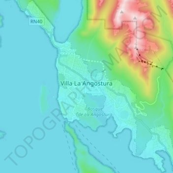
Name: Topografische Karte Villa La Angostura, Höhe, Relief.
Durchschnittliche Höhe: 928 m
Minimale Höhe: 759 m
Maximale Höhe: 1.824 m
The elevation of the city centre is about 790 m (2,590 ft), and the lake is at 765 m (2,510 ft). Surrounding mountains range from 1,500 m (4,900 ft) to about 2,000 m (6,600 ft) (Cerro Bayo, right behind the city, is 1,782 m (5,846 ft) high).