
Topografische Karte Santiago Atitlán
Interaktive Karte
Klicken Sie auf die Karte, um die Höhe anzuzeigen.
Über diese Karte
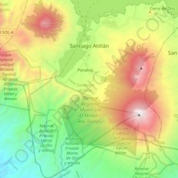
Name: Topografische Karte Santiago Atitlán, Höhe, Relief.
Ort: Santiago Atitlán, Sololá, Guatemala (14.53093 -91.28540 14.67625 -91.15029)
Durchschnittliche Höhe: 1.704 m
Minimale Höhe: 511 m
Maximale Höhe: 3.528 m
The town is situated on Lake Atitlán, which has an elevation of 5,105 feet (1,556 m). The town sits on a bay of Lake Atitlán between two volcanoes. Volcán San Pedro rises to 2,846 metres (9,337 ft) west of the town and Volcan Toliman rises to 3,144 metres (10,315 ft) southeast of the town. Volcán Atitlán, with an elevation of 3,516 metres (11,535 ft), is south-southeast of the town. Santiago Atitlan is southwest of Panajachel across the lake. Major highways reach Lake Atitlán at San Lucas Toliman and Panajachel. A road links Santiago to San Lucas Tolliman. Boats connect the numerous communities around the lake.
Andere topografische Karten
Klicken Sie auf eine Karte, um ihre Topografie, ihre Höhe und ihr Relief anzuzeigen.
Lake Atitlán
Guatemala > Sololá > San Pedro La Laguna
Lake Atitlán, San Pedro La Laguna, Sololá, 07013, Guatemala
Durchschnittliche Höhe: 1.782 m
Concepción
Guatemala > Sololá > Concepción
Concepción, Sololá, 07010, Guatemala
Durchschnittliche Höhe: 2.115 m
Panajachel
Guatemala > Sololá > Panajachel
Panajachel, Sololá, 07010, Guatemala
Durchschnittliche Höhe: 1.860 m
La Cuchilla
Guatemala > Sololá > La Cuchilla
La Cuchilla, Sololá, Guatemala
Durchschnittliche Höhe: 2.568 m
San Pablo La Laguna
San Pablo La Laguna, Sololá, Guatemala
Durchschnittliche Höhe: 1.862 m