
Topografische Karte Panajachel
Interaktive Karte
Klicken Sie auf die Karte, um die Höhe anzuzeigen.
Panajachel
Panajachel (Spanish pronunciation: , Pana) is a town in the southwestern Guatemalan Highlands, less than 90 miles from Guatemala City, in the department of Sololá. It serves as the administrative centre for the surrounding municipality of the same name. The elevation is 1,597 metres (5,240 ft). Population was 11 thousand in the 2000 census, estimated as 15,000 now (Insituto Nacional de Estadística de Guatemala), and has approximately doubled each of the last few decades. The town of Panajachel is located on the Northeast shore of Lake Atitlán, and has become a centre for the tourist trade of the area as it provides a base for visitors crossing the lake to visit other towns and villages.
Über diese Karte
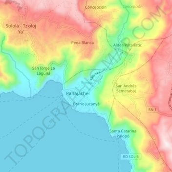
Name: Topografische Karte Panajachel, Höhe, Relief.
Ort: Panajachel, Sololá, 07010, Guatemala (14.70523 -91.19190 14.78523 -91.11190)
Durchschnittliche Höhe: 1.860 m
Minimale Höhe: 1.546 m
Maximale Höhe: 2.419 m