Geolokalisieren
👉 Easily get elevation data in JSON, GeoTIFF and KML formats using Elevation API
Vielen Dank für die Unterstützung dieser Website ❤️
Spenden

Topografische Karte Kuruva Island

Klicken Sie auf die Karte, um die Höhe anzuzeigen.

👉 Easily get elevation data in JSON, GeoTIFF and KML formats using Elevation API
Vielen Dank für die Unterstützung dieser Website ❤️
Spenden

Über diese Karte

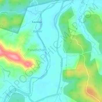
Name: Topografische Karte Kuruva Island, Höhe, Relief.

Ort: Kuruva Island, Sulthanbathery, Wayanad District, Kerala, India (11.80550 76.08514 11.83762 76.09906)

Durchschnittliche Höhe: 733 m

Minimale Höhe: 704 m

Maximale Höhe: 817 m

👉 Easily get elevation data in JSON, GeoTIFF and KML formats using Elevation API
Vielen Dank für die Unterstützung dieser Website ❤️
Spenden

Andere topografische Karten

Klicken Sie auf eine Karte, um ihre Topografie, ihre Höhe und ihr Relief anzuzeigen.

Meenangadi

India > Kerala > Sulthanbathery

Durchschnittliche Höhe: 760 m

Nadavayal

India > Kerala > Sulthanbathery

Durchschnittliche Höhe: 751 m

Seethamount

India > Kerala > Sulthanbathery > Kabanigiri

Durchschnittliche Höhe: 731 m

Ambalavayal

India > Kerala > Sulthanbathery

Durchschnittliche Höhe: 880 m

Vielen Dank für die Unterstützung dieser Website ❤️
Spenden

Rüsten Sie sich für Ihr nächstes Abenteuer:

Als Amazon-Partner erhält diese Website eine Provision für qualifizierte Käufe, ohne zusätzliche Kosten für Sie.

Kenichira

India > Kerala > Sulthanbathery

Durchschnittliche Höhe: 788 m

Paplassery

India > Kerala > Sulthanbathery

Durchschnittliche Höhe: 795 m

Kenichira

India > Kerala > Sulthanbathery

Durchschnittliche Höhe: 770 m

Nellarachal

India > Kerala > Sulthanbathery

Durchschnittliche Höhe: 781 m

Vadakkanad

India > Kerala > Sulthanbathery

Durchschnittliche Höhe: 896 m

Edakkal

India > Kerala > Sulthanbathery > Ambalavayal

Durchschnittliche Höhe: 927 m

Kalluvayal

India > Kerala > Sulthanbathery > Pulpally

Durchschnittliche Höhe: 816 m

Muthanga

India > Kerala > Sulthanbathery

Durchschnittliche Höhe: 866 m

Meenangadi

India > Kerala > Sulthanbathery

Durchschnittliche Höhe: 760 m

Sultan Bathery

India > Kerala > Sulthanbathery

Sultan Bathery is located at 11°40′N 76°17′E / 11.67°N 76.28°E / 11.67; 76.28, on the Kozhikode–Kollegal National Highway (NH 766) 97 kilometers from Kozhikode. It is 114 km from Mysore and about 100 km from Ooty (Udagamandalam). It is also connected with Nilambur. It has an average…

Durchschnittliche Höhe: 876 m

Sultan Bathery

India > Kerala > Sulthanbathery

Sulthan Bathery is located at 11°40′N 76°17′E / 11.67°N 76.28°E / 11.67; 76.28. It has an average elevation of 907 m (2,976 ft).

Durchschnittliche Höhe: 876 m

Sulthan Bathery

India > Kerala > Sulthanbathery > Sultan Bathery

Durchschnittliche Höhe: 873 m

Marakavu

India > Kerala > Sulthanbathery > Pulpally

Durchschnittliche Höhe: 769 m

Sulthan Bathery

India > Kerala > Sulthanbathery > Sultan Bathery

Durchschnittliche Höhe: 873 m

Muthanga

India > Kerala > Sulthanbathery

Durchschnittliche Höhe: 866 m

Koliyadi

India > Kerala > Sulthanbathery

Durchschnittliche Höhe: 886 m

Sultan Bathery

India > Kerala > Sulthanbathery

Sulthan Bathery is located at 11°40′N 76°17′E / 11.67°N 76.28°E / 11.67; 76.28. It has an average elevation of 907 m (2,976 ft).

Durchschnittliche Höhe: 876 m

Ambalavayal

India > Kerala > Sulthanbathery

Durchschnittliche Höhe: 880 m

Rüsten Sie sich für Ihr nächstes Abenteuer:

🧣Rettungsdecken - Schutz vor Auskühlung in Notsituationen
🩲Sportunterwäsche - Schnelltrocknend und scheuerfrei für lange Märsche
📡GPS-Tracker für Wanderer - Sicherheit durch Standortübermittlung an Angehörige
🧴Sport-Sonnencreme LSF 50 - Schweißresistenter Schutz vor Höhensonne
📍Verstellbare Wanderstöcke - Leichte und stabile Trekkingstöcke

Als Amazon-Partner erhält diese Website eine Provision für qualifizierte Käufe, ohne zusätzliche Kosten für Sie.