Geolokalisieren

Topografische Karte Victoria Island

Klicken Sie auf die Karte, um die Höhe anzuzeigen.

Über diese Karte

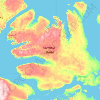
Name: Topografische Karte Victoria Island, Höhe, Relief.

Ort: Victoria Island, Canada (68.46092 -119.12422 73.37786 -100.84786)

Durchschnittliche Höhe: 104 m

Minimale Höhe: -2 m

Maximale Höhe: 778 m

Andere topografische Karten

Klicken Sie auf eine Karte, um ihre Topografie, ihre Höhe und ihr Relief anzuzeigen.

Toronto

Canada > Ontario > Toronto

Despite its deep ravines, Toronto is not remarkably hilly, but its elevation does increase steadily away from the lake. Elevation differences range from 76.5 metres (251 ft) above sea level at the Lake Ontario shore to 209 m (686 ft) ASL near the York University grounds in the city's north end at the…

Durchschnittliche Höhe: 113 m

Banff

Canada > Alberta > Banff > Banff

Banff is a town within Banff National Park in Alberta, Canada. It is located in Alberta's Rockies along the Trans-Canada Highway, approximately 126 km (78 mi) west of Calgary and 58 km (36 mi) east of Lake Louise. At 1,400 to 1,630 m (4,590 to 5,350 ft) above sea level, Banff is the community with the second…

Durchschnittliche Höhe: 1.615 m

London

Canada > Ontario > London > London

London has a humid continental climate (Köppen Dfb), though due to its downwind location relative to Lake Huron and elevation changes across the city, it is virtually on the Dfa/Dfb (hot summer) boundary favouring the former climate zone to the southwest of the confluence of the South and North Thames Rivers,…

Durchschnittliche Höhe: 268 m

Hamilton

Canada > Ontario > Hamilton

Durchschnittliche Höhe: 181 m

Vielen Dank für die Unterstützung dieser Website ❤️
Spenden

Rüsten Sie sich für Ihr nächstes Abenteuer:

Als Amazon-Partner erhält diese Website eine Provision für qualifizierte Käufe, ohne zusätzliche Kosten für Sie.

Minden

Canada > Ontario > Haliburton County > Minden Hills

Durchschnittliche Höhe: 320 m

Kleinburg

Canada > Ontario > York Region > Vaughan

Durchschnittliche Höhe: 206 m

St. John's

Canada > Newfoundland and Labrador > St. John's

Durchschnittliche Höhe: 66 m

Peterborough

Canada > Ontario > Peterborough

Peterborough's topography is largely defined by land formations created by the receding Wisconsian glaciers 10,000–15,000 years ago. The South End and Downtown portions of the City sit on what was the bottom of the glacial Lake Peterborough—part of a glacial spillway created when glacial meltwaters from…

Durchschnittliche Höhe: 235 m

North Maple Regional Park

Canada > Ontario > York Region > Vaughan

Durchschnittliche Höhe: 274 m

Maple Ridge

Canada > British Columbia > Maple Ridge

Durchschnittliche Höhe: 193 m

Guelph

Canada > Ontario > Guelph

This region of Ontario has cold winters and warm, humid summers, falling into the Köppen climate classification Dfb zone, with moderately high rainfall and snowfall. It is generally a couple of degrees cooler than lower elevation regions on the Great Lakes shorelines, especially so in winter, the exception…

Durchschnittliche Höhe: 344 m

Kawartha Lakes

Canada > Ontario > Kawartha Lakes

Durchschnittliche Höhe: 269 m

Victoria

Canada > British Columbia > Capital Regional District > Victoria

Durchschnittliche Höhe: 47 m

New Brunswick

Canada > New Brunswick

Durchschnittliche Höhe: 165 m

Calgary

Canada > Alberta > Calgary

Durchschnittliche Höhe: 1.106 m

Mount Logan

Canada > Yukon

Due to active tectonic uplifting, Mount Logan is still rising in height (approximately 0.35 mm per year). Before 1992, the exact elevation of Mount Logan was unknown and measurements ranged from 5,959 to 6,050 metres (19,551 to 19,849 ft). In May 1992, a GSC expedition climbed Mount Logan and fixed the current…

Durchschnittliche Höhe: 5.292 m

Vielen Dank für die Unterstützung dieser Website ❤️
Spenden

Haliburton

Canada > Ontario

Durchschnittliche Höhe: 358 m

Niagara Escarpment

Canada > Ontario

Durchschnittliche Höhe: 299 m

St. John River

Canada > New Brunswick

Durchschnittliche Höhe: 76 m

Thedford

Canada > Ontario > Lambton County > Lambton Shores

Durchschnittliche Höhe: 207 m

Vielen Dank für die Unterstützung dieser Website ❤️
Spenden

Capilano River

Canada > British Columbia > North Vancouver

Durchschnittliche Höhe: 841 m

North Vancouver

Canada > British Columbia > North Vancouver

Durchschnittliche Höhe: 258 m

Kingston

Canada > Ontario > Kingston

Durchschnittliche Höhe: 94 m

Cambridge

Canada > Ontario > Cambridge

Durchschnittliche Höhe: 295 m

Belleville

Canada > Ontario > Belleville

Durchschnittliche Höhe: 107 m

Red Deer

Canada > Alberta > Red Deer

Durchschnittliche Höhe: 918 m

Tottenham

Canada > Ontario > Simcoe County

Durchschnittliche Höhe: 274 m

Vielen Dank für die Unterstützung dieser Website ❤️
Spenden

Rüsten Sie sich für Ihr nächstes Abenteuer:

Als Amazon-Partner erhält diese Website eine Provision für qualifizierte Käufe, ohne zusätzliche Kosten für Sie.

Laurentian Mountains

Canada

One of Quebec's official regions is called Laurentides. The mountain range runs through four other regions; Capitale-Nationale, Outaouais, Lanaudière, and Mauricie. The elevation generally ranges from around 500 m (1,640 ft) to 1,000 m (3,280 ft) with Mont Raoul-Blanchard being its highest peak, at 1,166 m…

Durchschnittliche Höhe: 348 m

James Bay

Canada > Ontario > Nipissing District

Durchschnittliche Höhe: 217 m

Vielen Dank für die Unterstützung dieser Website ❤️
Spenden

Nunavik

Canada

Durchschnittliche Höhe: 191 m

Quetico Provincial Park

Canada > Ontario

Durchschnittliche Höhe: 432 m

White Hill

Canada > Nova Scotia > Cape Breton Highlands National Park > Cape Breton Highlands National Park

White Hill is a peak in the Cape Breton Highlands and is the highest elevation point in the province of Nova Scotia, Canada.

Durchschnittliche Höhe: 488 m

Cypress Hills

Canada > Saskatchewan

Durchschnittliche Höhe: 1.183 m

Lake Louise

Canada > Alberta > Improvement District No. 9

Lake Louise is a hamlet within Banff National Park in Alberta, Canada. Named after Princess Louise, Duchess of Argyll, it lies in Alberta's Rockies on the Bow River, 3 km (1.9 mi) northeast of the lake that shares its name. Initially settled in 1884 as an outpost for the Canadian Pacific Railway, Lake Louise…

Durchschnittliche Höhe: 1.617 m

Ogilvie Mountains

Canada > Yukon

Durchschnittliche Höhe: 683 m

Richardson Mountains

Canada > Yukon

Durchschnittliche Höhe: 679 m

Vielen Dank für die Unterstützung dieser Website ❤️
Spenden

Rüsten Sie sich für Ihr nächstes Abenteuer:

Als Amazon-Partner erhält diese Website eine Provision für qualifizierte Käufe, ohne zusätzliche Kosten für Sie.

Mount Steele

Canada > Yukon

Mount Steele is the fifth-highest mountain in Canada and either the tenth- or eleventh-highest peak in North America. Its exact elevation is uncertain. Commonly-quoted figures are 5,073 metres (16,644 ft) and 5,020 metres (16,470 ft). A lower southeast peak of Mt. Steele stands at 4,300 m (14,100 ft).

Durchschnittliche Höhe: 4.446 m

Smith

Canada > Alberta > Municipal District of Lesser Slave River

Durchschnittliche Höhe: 592 m

Moose Factory

Canada > Ontario > Cochrane District

Durchschnittliche Höhe: 5 m

Val Caron

Canada > Ontario > Sudbury District > Greater Sudbury

Durchschnittliche Höhe: 295 m

Burnaby

Canada > British Columbia > Metro Vancouver Regional District > Burnaby

Burnaby occupies 98.60 square kilometres (38.07 sq mi) and is located at the geographic centre of the Metro Vancouver area and home to the Metro Vancouver regional government in Metrotown. Situated between the city of Vancouver on the west and Port Moody, Coquitlam, and New Westminster on the east, Burnaby is…

Durchschnittliche Höhe: 144 m

Winnipeg (city)

Canada > Manitoba

Durchschnittliche Höhe: 253 m

Muskoka River

Canada > Ontario > Muskoka District > Bracebridge

Durchschnittliche Höhe: 246 m

Mount Robson

Canada > British Columbia > Regional District of Fraser-Fort George > Area H (Robson Valley/Canoe)

The north face can be seen from Berg Lake, and reached by a 19 km (11.8 mi) hike. The lake is approximately 2 km long and lies at 1,646 m (5,400 ft) elevation. There are backcountry campgrounds at each end of the lake and a log shelter on its banks, named Hargreaves Shelter in honor of the Hargreaves family…

Durchschnittliche Höhe: 3.042 m

Vielen Dank für die Unterstützung dieser Website ❤️
Spenden

Rüsten Sie sich für Ihr nächstes Abenteuer:

Als Amazon-Partner erhält diese Website eine Provision für qualifizierte Käufe, ohne zusätzliche Kosten für Sie.

Markdale

Canada > Ontario > Grey County > Grey Highlands

Durchschnittliche Höhe: 421 m

Cochrane

Canada > Alberta > Town of Cochrane > Cochrane

Cochrane is situated at the base of Big Hill in the Bow River Valley. It sits at an elevation of 1,186 m (3,891 ft). The town is intersected by Highway 1A and Highway 22. Cochrane has a reputation for its western culture, which can easily be felt when one wanders the streets (particularly Main Street). The…

Durchschnittliche Höhe: 1.205 m

Crowsnest Pass

Canada > Alberta > Crowsnest Pass

Durchschnittliche Höhe: 1.410 m

Paradise

Canada > Newfoundland and Labrador > Paradise

Durchschnittliche Höhe: 150 m

Vielen Dank für die Unterstützung dieser Website ❤️
Spenden

Rüsten Sie sich für Ihr nächstes Abenteuer:

Als Amazon-Partner erhält diese Website eine Provision für qualifizierte Käufe, ohne zusätzliche Kosten für Sie.

Sackville

Canada > New Brunswick > Westmorland County > Sackville

Durchschnittliche Höhe: 31 m

Volcano Mountain

Canada > Yukon

Durchschnittliche Höhe: 940 m

Seward Glacier

Canada > Yukon

Durchschnittliche Höhe: 1.846 m

Walsh Glacier

Canada > Yukon

Durchschnittliche Höhe: 2.675 m

Vielen Dank für die Unterstützung dieser Website ❤️
Spenden

Donjek Glacier

Canada > Yukon

Durchschnittliche Höhe: 1.789 m

Pelly Mountains

Canada > Yukon

Durchschnittliche Höhe: 1.187 m

Selwyn Mountains

Canada > Yukon

Durchschnittliche Höhe: 1.006 m

Mackenzie Mountains

Canada > Yukon

Durchschnittliche Höhe: 2.340 m

Mount Slaggard

Canada > Yukon

Durchschnittliche Höhe: 4.229 m

Mount Vancouver

Canada > Yukon

Durchschnittliche Höhe: 3.901 m

King Peak

Canada > Yukon

Durchschnittliche Höhe: 4.122 m

Mount Saint Elias

Canada > Yukon

Durchschnittliche Höhe: 4.672 m

Saskatoon (city)

Canada > Saskatchewan

Durchschnittliche Höhe: 545 m

Regina (city)

Canada > Saskatchewan

Durchschnittliche Höhe: 602 m

Peace River (town)

Canada > Alberta

Durchschnittliche Höhe: 627 m

Grande Prairie (city)

Canada > Alberta

Durchschnittliche Höhe: 761 m

Swift Current

Canada > Newfoundland and Labrador

Durchschnittliche Höhe: 130 m

Stony Mountain

Canada > Manitoba

Durchschnittliche Höhe: 238 m

Snag

Canada > Yukon

Durchschnittliche Höhe: 553 m

Sheppardville

Canada > Newfoundland and Labrador

Durchschnittliche Höhe: 114 m

Vielen Dank für die Unterstützung dieser Website ❤️
Spenden

Old Crow

Canada > Newfoundland and Labrador

Durchschnittliche Höhe: 417 m

Red Deer (city)

Canada > Alberta

Durchschnittliche Höhe: 924 m

Humber River

Canada > Ontario > Toronto

Durchschnittliche Höhe: 82 m

Highlands

Canada > Newfoundland and Labrador

Durchschnittliche Höhe: 17 m

Saint Elias Mountains

Canada > Yukon

Durchschnittliche Höhe: 4.403 m

Middlechurch

Canada > Manitoba

Durchschnittliche Höhe: 231 m

Saumarez Parish

Canada > New Brunswick

Durchschnittliche Höhe: 0 m

British Columbia

Canada

Durchschnittliche Höhe: 35 m

Vielen Dank für die Unterstützung dieser Website ❤️
Spenden

Rüsten Sie sich für Ihr nächstes Abenteuer:

Als Amazon-Partner erhält diese Website eine Provision für qualifizierte Käufe, ohne zusätzliche Kosten für Sie.

Ohsweken

Canada > Ontario

Durchschnittliche Höhe: 208 m

Angus

Canada > Ontario > Simcoe County > Essa

Durchschnittliche Höhe: 199 m

Lac-Simon

Canada > Quebec

Durchschnittliche Höhe: 321 m

The Cabox

Canada > Newfoundland and Labrador

Durchschnittliche Höhe: 698 m

Dollars Lake

Canada > Ontario > Unorganized Centre Parry Sound

Durchschnittliche Höhe: 222 m

Grand Bank

Canada > Newfoundland and Labrador

Durchschnittliche Höhe: 23 m

Caroline

Canada > Alberta

Durchschnittliche Höhe: 1.066 m

Summerside

Canada > Prince Edward Island > Summerside

Durchschnittliche Höhe: 13 m

Stanhope

Canada > Newfoundland and Labrador

Durchschnittliche Höhe: 7 m

White Bear Lake

Canada > Saskatchewan

Durchschnittliche Höhe: 741 m

Shell Lake

Canada > Saskatchewan > Spiritwood No. 496

Durchschnittliche Höhe: 568 m

Ottawa

Canada > Ontario > Ottawa > Ottawa

Durchschnittliche Höhe: 99 m

NU

Canada > NU

Durchschnittliche Höhe: 1 m

Halifax

Canada > Nova Scotia

Durchschnittliche Höhe: 60 m

Trenton

Canada > Ontario > Quinte West

Durchschnittliche Höhe: 89 m

White Head

Canada > New Brunswick > Grand Manan Parish

Durchschnittliche Höhe: 2 m

Niagara Escarpment

Canada > Ontario > Burlington

Durchschnittliche Höhe: 216 m

Saskatoon

Canada > Saskatchewan > Saskatoon

Durchschnittliche Höhe: 492 m

Kennebecasis River

Canada > New Brunswick

Durchschnittliche Höhe: 73 m

Rüsten Sie sich für Ihr nächstes Abenteuer:

🔭Spektive - Hochleistungsoptik für weite Distanzen im Gebirge
🛰️Satelliten-Kommunikation - Notfall-Messenger für Gebiete ohne Mobilfunkempfang
🧦Kompressionsstrümpfe - Unterstützend bei langen Touren
🔥Ultraleichter Campingkocher - Kompaktes Kochsystem für Rucksacktouren
🩴Camping Sandalen - Bequeme Sandalen für Basislager

Als Amazon-Partner erhält diese Website eine Provision für qualifizierte Käufe, ohne zusätzliche Kosten für Sie.