
Topografische Karte St. Patrick Road
Interaktive Karte
Klicken Sie auf die Karte, um die Höhe anzuzeigen.
Über diese Karte
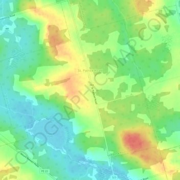
Name: Topografische Karte St. Patrick Road, Höhe, Relief.
Ort: St. Patrick Road, Kings County, Prince Edward Island, Canada (46.30483 -62.80864 46.34598 -62.75415)
Durchschnittliche Höhe: 45 m
Minimale Höhe: 21 m
Maximale Höhe: 78 m
Andere topografische Karten
Klicken Sie auf eine Karte, um ihre Topografie, ihre Höhe und ihr Relief anzuzeigen.
Albion
Canada > Prince Edward Island > Kings County
Albion, Town of Three Rivers, Kings County, Prince Edward Island, Canada
Durchschnittliche Höhe: 13 m
Sturgeon
Canada > Prince Edward Island > Kings County
Sturgeon, Town of Three Rivers, Kings County, Prince Edward Island, Canada
Durchschnittliche Höhe: 12 m
Georgetown
Canada > Prince Edward Island > Kings County
Georgetown, Town of Three Rivers, Kings County, Prince Edward Island, Canada
Durchschnittliche Höhe: 9 m
Maitland Flat
Canada > Prince Edward Island > Kings County > DeGros Marsh
Maitland Flat, DeGros Marsh, Town of Three Rivers, Kings County, Prince Edward Island, Canada
Durchschnittliche Höhe: 5 m
Cardigan
Canada > Prince Edward Island > Kings County > Cardigan
Cardigan, Town of Three Rivers, Kings County, Prince Edward Island, Canada
Durchschnittliche Höhe: 27 m
Lower Montague
Canada > Prince Edward Island > Kings County > Lower Montague
Lower Montague, Town of Three Rivers, Kings County, Prince Edward Island, C0A 1R0, Canada
Durchschnittliche Höhe: 15 m
Souris
Canada > Prince Edward Island > Kings County
Souris, Kings County, Prince Edward Island, Canada
Durchschnittliche Höhe: 33 m