
Spenden
Rüsten Sie sich für Ihr nächstes Abenteuer:
Als Amazon-Partner erhält diese Website eine Provision für qualifizierte Käufe, ohne zusätzliche Kosten für Sie.
Topografische Karte Souris
Klicken Sie auf die Karte, um die Höhe anzuzeigen.
Spenden
Rüsten Sie sich für Ihr nächstes Abenteuer:
Als Amazon-Partner erhält diese Website eine Provision für qualifizierte Käufe, ohne zusätzliche Kosten für Sie.
Über diese Karte
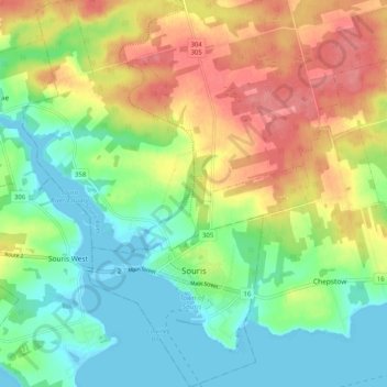
Name: Topografische Karte Souris, Höhe, Relief.
Ort: Souris, Kings County, Prince Edward Island, C0A 2B0, Canada (46.33544 -62.29540 46.40542 -62.22013)
Durchschnittliche Höhe: 33 m
Minimale Höhe: -3 m
Maximale Höhe: 79 m
Spenden
Rüsten Sie sich für Ihr nächstes Abenteuer:
Als Amazon-Partner erhält diese Website eine Provision für qualifizierte Käufe, ohne zusätzliche Kosten für Sie.
Andere topografische Karten
Klicken Sie auf eine Karte, um ihre Topografie, ihre Höhe und ihr Relief anzuzeigen.
Prince Edward Island National Park
Canada > Prince Edward Island > Kings County > Greenwich
Durchschnittliche Höhe: 2 m