
Topografische Karte Bouillé-Saint-Paul
Interaktive Karte
Klicken Sie auf die Karte, um die Höhe anzuzeigen.
Über diese Karte
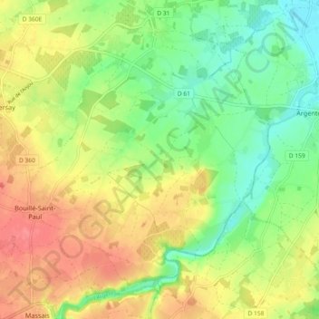
Name: Topografische Karte Bouillé-Saint-Paul, Höhe, Relief.
Durchschnittliche Höhe: 74 m
Minimale Höhe: 43 m
Maximale Höhe: 107 m
Andere topografische Karten
Klicken Sie auf eine Karte, um ihre Topografie, ihre Höhe und ihr Relief anzuzeigen.
La Maynie
France > Nouvelle-Aquitaine > Deux-Sèvres > Val en Vignes > La Maynie
La Maynie, Massais, Val en Vignes, Bressuire, Deux-Sèvres, Nouvelle-Aquitaine, France métropolitaine, 79150, France
Durchschnittliche Höhe: 93 m
Vaucouleur
France > Nouvelle-Aquitaine > Deux-Sèvres > Val en Vignes
Vaucouleur, Massais, Val en Vignes, Bressuire, Deux-Sèvres, Nouvelle-Aquitaine, France métropolitaine, 79150, France
Durchschnittliche Höhe: 93 m
Le Pain Bénit
France > Nouvelle-Aquitaine > Deux-Sèvres > Val en Vignes > Le Pain Bénit
Le Pain Bénit, Massais, Val en Vignes, Bressuire, Deux-Sèvres, Nouvelle-Aquitaine, France métropolitaine, 79150, France
Durchschnittliche Höhe: 96 m
Cersay
France > Nouvelle-Aquitaine > Deux-Sèvres > Val en Vignes
Cersay, Val en Vignes, Bressuire, Deux-Sèvres, Nouvelle-Aquitaine, France métropolitaine, 79290, France
Durchschnittliche Höhe: 87 m
Massais
France > Nouvelle-Aquitaine > Deux-Sèvres > Val en Vignes
Massais, Val en Vignes, Bressuire, Deux-Sèvres, Nouvelle-Aquitaine, France métropolitaine, 79150, France
Durchschnittliche Höhe: 100 m