Geolokalisieren

Topografische Karte Vaucouleur

Interaktive Karte

Klicken Sie auf die Karte, um die Höhe anzuzeigen.

Über diese Karte

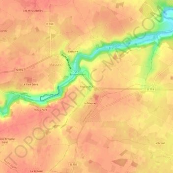
Name: Topografische Karte Vaucouleur, Höhe, Relief.

Ort: Vaucouleur, Massais, Val en Vignes, Bressuire, Deux-Sèvres, Nouvelle-Aquitaine, France métropolitaine, 79150, France (46.97974 -0.35385 47.01974 -0.31385)

Durchschnittliche Höhe: 93 m

Minimale Höhe: 52 m

Maximale Höhe: 105 m

Andere topografische Karten

Klicken Sie auf eine Karte, um ihre Topografie, ihre Höhe und ihr Relief anzuzeigen.

La Maynie

France > Nouvelle-Aquitaine > Deux-Sèvres > Val en Vignes > La Maynie

La Maynie, Massais, Val en Vignes, Bressuire, Deux-Sèvres, Nouvelle-Aquitaine, France métropolitaine, 79150, France

Durchschnittliche Höhe: 93 m

Le Pain Bénit

France > Nouvelle-Aquitaine > Deux-Sèvres > Val en Vignes > Le Pain Bénit

Le Pain Bénit, Massais, Val en Vignes, Bressuire, Deux-Sèvres, Nouvelle-Aquitaine, France métropolitaine, 79150, France

Durchschnittliche Höhe: 96 m

Cersay

France > Nouvelle-Aquitaine > Deux-Sèvres > Val en Vignes

Cersay, Val en Vignes, Bressuire, Deux-Sèvres, Nouvelle-Aquitaine, France métropolitaine, 79290, France

Durchschnittliche Höhe: 87 m

Massais

France > Nouvelle-Aquitaine > Deux-Sèvres > Val en Vignes

Massais, Val en Vignes, Bressuire, Deux-Sèvres, Nouvelle-Aquitaine, France métropolitaine, 79150, France

Durchschnittliche Höhe: 100 m

Bouillé-Saint-Paul

France > Nouvelle-Aquitaine > Deux-Sèvres > Val en Vignes

Bouillé-Saint-Paul, Val en Vignes, Bressuire, Deux-Sèvres, Nouvelle-Aquitaine, France métropolitaine, 79290, France

Durchschnittliche Höhe: 74 m