
Topografische Karte Monchiero
Interaktive Karte
Klicken Sie auf die Karte, um die Höhe anzuzeigen.
Über diese Karte
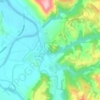
Name: Topografische Karte Monchiero, Höhe, Relief.
Ort: Monchiero, Cuneo, Piedmont, Italy (44.55407 7.90128 44.58264 7.94244)
Durchschnittliche Höhe: 264 m
Minimale Höhe: 210 m
Maximale Höhe: 418 m
Andere topografische Karten
Klicken Sie auf eine Karte, um ihre Topografie, ihre Höhe und ihr Relief anzuzeigen.
Bersia
Italy > Piedmont > Cuneo > San Damiano Macra
Bersia, San Damiano Macra, Cuneo, Piedmont, 12020, Italy
Durchschnittliche Höhe: 1.336 m
Fre
Italy > Piedmont > Cuneo > Montemale di Cuneo
Fre, Montemale di Cuneo, Cuneo, Piedmont, Italy
Durchschnittliche Höhe: 997 m
Giardino Famiglia Allemandi
Italy > Piedmont > Cuneo > Villar San Costanzo > Pramallé
Giardino Famiglia Allemandi, Pramallé, Villar San Costanzo, Cuneo, Piedmont, Italy
Durchschnittliche Höhe: 654 m
Punta Razil
Italy > Piedmont > Cuneo > Bagnolo Piemonte
Punta Razil, Bagnolo Piemonte, Cuneo, Piedmont, Italy
Durchschnittliche Höhe: 2.008 m
Pontechianale
Pontechianale, Cuneo, Piedmont, Italy
Durchschnittliche Höhe: 2.447 m
Limone Piemonte
Limone Piemonte, Cuneo, Piedmont, 12015, Italy
Durchschnittliche Höhe: 1.619 m