
Topografische Karte Argentera
Interaktive Karte
Klicken Sie auf die Karte, um die Höhe anzuzeigen.
Über diese Karte
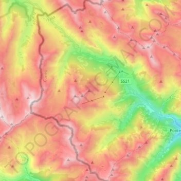
Name: Topografische Karte Argentera, Höhe, Relief.
Ort: Argentera, Cuneo, Piedmont, Italy (44.31929 6.88701 44.42996 7.03051)
Durchschnittliche Höhe: 2.195 m
Minimale Höhe: 1.245 m
Maximale Höhe: 2.935 m
Argentera borders the following municipalities: Acceglio, Canosio, Larche (France), Pietraporzio, and Saint-Etienne-de-Tinée (France). Its territory includes peaks such as the Oserot at an elevation of 2,860 metres (9,380 ft) above sea level, Enciastraia at 2,955 metres (9,695 ft) and the Rocca dei Tre Vescovi at 2,867 metres (9,406 ft).
Andere topografische Karten
Klicken Sie auf eine Karte, um ihre Topografie, ihre Höhe und ihr Relief anzuzeigen.
Bersia
Italy > Piedmont > Cuneo > San Damiano Macra
Bersia, San Damiano Macra, Cuneo, Piedmont, 12020, Italy
Durchschnittliche Höhe: 1.336 m
Fre
Italy > Piedmont > Cuneo > Montemale di Cuneo
Fre, Montemale di Cuneo, Cuneo, Piedmont, Italy
Durchschnittliche Höhe: 997 m
Giardino Famiglia Allemandi
Italy > Piedmont > Cuneo > Villar San Costanzo > Pramallé
Giardino Famiglia Allemandi, Pramallé, Villar San Costanzo, Cuneo, Piedmont, Italy
Durchschnittliche Höhe: 654 m
Punta Razil
Italy > Piedmont > Cuneo > Bagnolo Piemonte
Punta Razil, Bagnolo Piemonte, Cuneo, Piedmont, Italy
Durchschnittliche Höhe: 2.008 m
Pontechianale
Pontechianale, Cuneo, Piedmont, Italy
Durchschnittliche Höhe: 2.447 m
Limone Piemonte
Limone Piemonte, Cuneo, Piedmont, 12015, Italy
Durchschnittliche Höhe: 1.619 m