
Topografische Karte Bačka
Interaktive Karte
Klicken Sie auf die Karte, um die Höhe anzuzeigen.
Über diese Karte
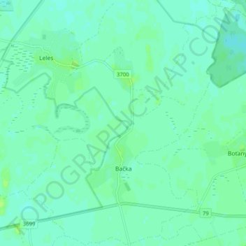
Name: Topografische Karte Bačka, Höhe, Relief.
Durchschnittliche Höhe: 101 m
Minimale Höhe: 97 m
Maximale Höhe: 106 m
The village lies at an altitude of 104 metres and covers an area of 9.578 km². It has a population of about 600 people.
Andere topografische Karten
Klicken Sie auf eine Karte, um ihre Topografie, ihre Höhe und ihr Relief anzuzeigen.
Bara
Slovakia > Region of Košice > District of Trebišov
Bara, District of Trebišov, Region of Košice, Eastern Slovakia, Slovakia
Durchschnittliche Höhe: 160 m
Streda nad Bodrogom
Slovakia > Region of Košice > District of Trebišov
Streda nad Bodrogom, District of Trebišov, Region of Košice, Eastern Slovakia, 076 31, Slovakia
Durchschnittliche Höhe: 106 m
Boťany
Slovakia > Region of Košice > District of Trebišov
Boťany, District of Trebišov, Region of Košice, Eastern Slovakia, 076 43, Slovakia
Durchschnittliche Höhe: 101 m