
Topografische Karte Streda nad Bodrogom
Interaktive Karte
Klicken Sie auf die Karte, um die Höhe anzuzeigen.
Über diese Karte
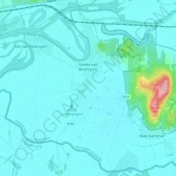
Name: Topografische Karte Streda nad Bodrogom, Höhe, Relief.
Durchschnittliche Höhe: 106 m
Minimale Höhe: 88 m
Maximale Höhe: 272 m
The village has the lowest altitude (94 metres (308 ft) above sea level) in Slovakia.
Andere topografische Karten
Klicken Sie auf eine Karte, um ihre Topografie, ihre Höhe und ihr Relief anzuzeigen.
Bačka
Slovakia > Region of Košice > District of Trebišov
Bačka, District of Trebišov, Region of Košice, Eastern Slovakia, Slovakia
Durchschnittliche Höhe: 101 m
Bara
Slovakia > Region of Košice > District of Trebišov
Bara, District of Trebišov, Region of Košice, Eastern Slovakia, Slovakia
Durchschnittliche Höhe: 160 m
Boťany
Slovakia > Region of Košice > District of Trebišov
Boťany, District of Trebišov, Region of Košice, Eastern Slovakia, 076 43, Slovakia
Durchschnittliche Höhe: 101 m