
Topografische Karte Fontaine
Interaktive Karte
Klicken Sie auf die Karte, um die Höhe anzuzeigen.
Über diese Karte
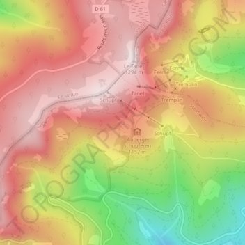
Name: Topografische Karte Fontaine, Höhe, Relief.
Durchschnittliche Höhe: 1.079 m
Minimale Höhe: 761 m
Maximale Höhe: 1.282 m
Andere topografische Karten
Klicken Sie auf eine Karte, um ihre Topografie, ihre Höhe und ihr Relief anzuzeigen.
Trois Fours
France > Grand Est > Haut-Rhin > Stosswihr
Trois Fours, Stosswihr, Colmar-Ribeauvillé, Haut-Rhin, Grand Est, France métropolitaine, 68140, France
Durchschnittliche Höhe: 1.037 m
Ampfersbach
France > Grand Est > Haut-Rhin > Stosswihr
Ampfersbach, Stosswihr, Colmar-Ribeauvillé, Haut-Rhin, Grand Est, France métropolitaine, 68140, France
Durchschnittliche Höhe: 634 m