Geolokalisieren

Topografische Karte Gaschney

Interaktive Karte

Klicken Sie auf die Karte, um die Höhe anzuzeigen.

Über diese Karte

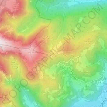
Name: Topografische Karte Gaschney, Höhe, Relief.

Ort: Gaschney, Stosswihr, Colmar-Ribeauvillé, Haut-Rhin, Grand Est, France métropolitaine, 68140, France (48.01419 7.02656 48.05419 7.06656)

Durchschnittliche Höhe: 873 m

Minimale Höhe: 467 m

Maximale Höhe: 1.350 m

Andere topografische Karten

Klicken Sie auf eine Karte, um ihre Topografie, ihre Höhe und ihr Relief anzuzeigen.

Trois Fours

France > Grand Est > Haut-Rhin > Stosswihr

Trois Fours, Stosswihr, Colmar-Ribeauvillé, Haut-Rhin, Grand Est, France métropolitaine, 68140, France

Durchschnittliche Höhe: 1.037 m

Ampfersbach

France > Grand Est > Haut-Rhin > Stosswihr

Ampfersbach, Stosswihr, Colmar-Ribeauvillé, Haut-Rhin, Grand Est, France métropolitaine, 68140, France

Durchschnittliche Höhe: 634 m

Hohneck

France > Grand Est > Haut-Rhin > Stosswihr

Hohneck, Stosswihr, Colmar-Ribeauvillé, Haut-Rhin, Grand Est, France métropolitaine, 68140, France

Durchschnittliche Höhe: 1.136 m

Fontaine

France > Grand Est > Haut-Rhin > Stosswihr

Fontaine, La Schantz, Schanzwasen, Stosswihr, Colmar-Ribeauvillé, Haut-Rhin, Grand Est, France métropolitaine, 68140, France

Durchschnittliche Höhe: 1.079 m