Geolokalisieren

Topografische Karte Yamuna

Klicken Sie auf die Karte, um die Höhe anzuzeigen.

Yamuna

The source of Yamuna lies in the Yamunotri Glacier at an elevation of 6,387 metres (20,955 ft), on the southwestern slopes of Banderpooch peaks, which lie in the Mussoorie range of the Lower Himalayas, north of Haridwar in Uttarkashi district, Uttarakhand. Yamunotri temple, a shrine dedicated to the goddess Yamuna, is one of the holiest shrines in Hinduism, and part of the Chota Char Dham Yatra circuit. Also standing close to the temple, on its 13-kilometre (8 mi) trek route that follows the right bank of the river, lies Markendeya Tirtha, where the sage Markandeya wrote the Markandeya Purana.

Wikipedia (CC-BY-SA 3.0)

Über diese Karte

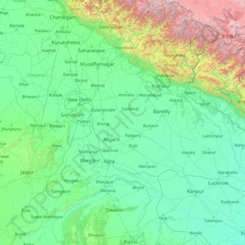
Name: Topografische Karte Yamuna, Höhe, Relief.

Ort: Yamuna, India (25.25727 77.09509 31.02743 81.89233)

Durchschnittliche Höhe: 707 m

Minimale Höhe: 75 m

Maximale Höhe: 7.431 m

Andere topografische Karten

Klicken Sie auf eine Karte, um ihre Topografie, ihre Höhe und ihr Relief anzuzeigen.

Pune

India > Maharashtra > Pune City Subdistrict

Durchschnittliche Höhe: 641 m

Ludhiana

India > Punjab > Ludhiana (West) Tahsil

Ludhiana is located at 30°54′N 75°51′E / 30.9°N 75.85°E / 30.9; 75.85. It has an average elevation of 244 metres (801 ft). Ludhiana City, to its residents, consists of the Old City and the New City. The new city primarily consists of the Civil Lines area which was historically known as the…

Durchschnittliche Höhe: 247 m

3d

India > Rajasthan > Ganganagar Tehsil > 1 LNP

Durchschnittliche Höhe: 178 m

Lucknow

India > Uttar Pradesh > Lucknow

Lucknow stands at an elevation of approximately 123 metres (404 ft) above sea level. The city had an area of 402 km2 (155 square miles) until December 2019, when 88 villages were added to the municipal limits and the area increased to 631 km2 (244 square miles). Bounded on the east by Barabanki, on the west by…

Durchschnittliche Höhe: 120 m

Mumbai

India > Maharashtra

Mumbai lies at the mouth of the Ulhas River on the western coast of India, in the coastal region known as the Konkan. It sits on Salsette Island (Sashti Island), which it partially shares with the Thane district. Mumbai is bounded by the Arabian Sea to the west. Many parts of the city lie just above sea level,…

Durchschnittliche Höhe: 13 m

Gujarat

India

Durchschnittliche Höhe: 124 m

Udhagamandalam

India > Tamil Nadu > Udhagamandalam

Ooty is situated in the Nilgiri Biosphere Reserve. Many of the forested areas and water bodies are off-limits to most visitors in order to protect this fragile ecosystem. Some areas of the Biosphere Reserve have been earmarked for tourism development, and steps are being undertaken to open these areas to…

Durchschnittliche Höhe: 2.234 m

Thiruvananthapuram

India > Kerala > Thiruvananthapuram

Thiruvananthapuram is built on seven hills by the seashore and is at 8°30′N 76°54′E / 8.5°N 76.9°E / 8.5; 76.9 on the west coast, near the southern tip of mainland India. The city is on the west coast of India and is bounded by the Laccadive Sea to its west and the Western Ghats to its east.…

Durchschnittliche Höhe: 33 m

Dehradun

India > Uttarakhand > Dehradun

The city of Dehradun mainly lies in Doon Valley and is at a varying height from 410 m (1,350 ft) in Clement Town to above 700 m (2,300 ft) at Malsi which is 15 km (9.3 mi) from the city. However, the average elevation is 450 m (1,480 ft) above sea level. Malsi is the starting point of Lesser Himalayan Range…

Durchschnittliche Höhe: 904 m

Chennai

India > Tamil Nadu

Chennai is located on the south–eastern coast of India in the north–eastern part of Tamil Nadu on a flat coastal plain known as the Eastern Coastal Plains. Its average elevation is around 6.7 metres (22 ft), and its highest point is 60 m (200 ft). Chennai is 2,184 kilometres (1,357 mi) south of Delhi,…

Durchschnittliche Höhe: 7 m

Manimangalam

India > Tamil Nadu

Durchschnittliche Höhe: 21 m

Western Ghats

India > Kerala > Devikulam

The range starts near south of the Tapti river and runs approximately 1,600 km (990 mi) through the states of Gujarat, Maharashtra, Karnataka, Goa, Kerala and Tamil Nadu ending at Marunthuvazh Malai near the southern tip of India. These hills cover 160,000 km2 (62,000 sq mi) and form the catchment area for…

Durchschnittliche Höhe: 2.225 m

Visakhapatnam

India > Andhra Pradesh > Visakhapatnam (Urban)

The city is situated between the Eastern Ghats and the Bay of Bengal. The city coordinates lies between 17.7041 N and 83.2977 E. The city's area is 682 km2. The average elevation is 45 metres. Visakhpatnam is situated in Coastal Andhra Region.

Durchschnittliche Höhe: 35 m

Jamnagar

India > Gujarat

Durchschnittliche Höhe: 51 m

Chathari

India > Kerala > Kanayannur > Thrippunithura > Chathari

Durchschnittliche Höhe: 8 m

Chandannagar

India > West Bengal > Singur

Chandannagar is located at 22°52′N 88°23′E / 22.87°N 88.38°E / 22.87; 88.38. It has an average elevation of 10 metres (33 ft).

Durchschnittliche Höhe: 8 m

Vielen Dank für die Unterstützung dieser Website ❤️
Spenden

Rüsten Sie sich für Ihr nächstes Abenteuer:

Als Amazon-Partner erhält diese Website eine Provision für qualifizierte Käufe, ohne zusätzliche Kosten für Sie.

Lansdowne

India > Uttarakhand > Lansdowne

Lansdowne is a quaint hill station in the Pauri Garhwal district of Uttarakhand, India. Lodged in the picturesque surroundings of the Himalayan ranges, it lies at an elevation of approximately 1,700 meters (5,577 feet) above sea level. The town is about 45 kilometers (28 miles) from the district headquarters,…

Durchschnittliche Höhe: 1.140 m

Dhanbad

India > Jharkhand > Dhanbad-Cum-Kenduadih-Cum-Jagata

Dhanbad has an average elevation of 227 m (745 ft). Its geographical length (extending from north to south) is 15 miles (24 km) and the breadth (stretching across east to West) is 10 miles (16 km). It shares its boundaries with West Bengal in the eastern and southern part, Giridih and Dumka in the North and…

Durchschnittliche Höhe: 212 m

Tungabhadra Dam

India > Karnataka > Hosapete taluk > Hosapete

Durchschnittliche Höhe: 491 m

Joshimath

India > Uttarakhand > Joshimath Tehsil

Durchschnittliche Höhe: 2.272 m

Maithon Reservoir

India > Jharkhand > Jamtara > Mihijam

Durchschnittliche Höhe: 157 m

Bironkhal

India > Uttarakhand > Thailisain

Durchschnittliche Höhe: 1.439 m

Bahraich

India > Uttar Pradesh > Bahraich

It has an average elevation of 126 metres (413 feet). Bahraich has a warm humid subtropical climate with hot summers from April to July. The rainy season is from July to mid-September when Bahraich gets an average rainfall from the south-west monsoon winds, and occasionally frontal rainfall will occur in…

Durchschnittliche Höhe: 120 m

Chunt Valiwar

India > Jammu and Kashmir > Lar

Durchschnittliche Höhe: 2.125 m

Maharashtra

India > Maharashtra

Maharashtra is the third largest state by area in India. The Western Ghats better known as Sahyadri, are a hilly range running parallel to the coast, at an average elevation of 1,200 metres (4,000 ft). Kalsubai, a peak in the Sahyadris, near Nashik city is the highest elevated point in Maharashtra. To the west…

Durchschnittliche Höhe: 478 m

Pannaikadu

India > Tamil Nadu > Kodaikanal

Durchschnittliche Höhe: 1.288 m

Aravalli Range

India > Rajasthan > Abu Road Tehsil

Durchschnittliche Höhe: 1.339 m

Western Ghats

India > Kerala > Devikulam

The range starts near south of the Tapti river and runs approximately 1,600 km (990 mi) through the states of Gujarat, Maharashtra, Karnataka, Goa, Kerala and Tamil Nadu ending at Marunthuvazh Malai, Swamithope near the southern tip of India. These hills cover 160,000 km2 (62,000 sq mi) and form the catchment…

Durchschnittliche Höhe: 2.225 m

Kelambakkam

India > Tamil Nadu > Tiruporur

Durchschnittliche Höhe: 5 m

Leh

India > Ladakh

Leh (/ˈlɛ/) (Ladakhi: གླེ) is the joint capital and largest city of Ladakh, a union territory of India. Leh, located in the Leh district, was also the historical capital of the Kingdom of Ladakh, the seat of which was in the Leh Palace, the former residence of the royal family of Ladakh, built in the…

Durchschnittliche Höhe: 4.294 m

Shimla

India > Himachal Pradesh

Shimla is on the south-western ranges of the Himalayas at 31°37′N 77°06′E / 31.61°N 77.10°E / 31.61; 77.10. It has an average altitude of 2,206 metres (7,238 ft) above mean sea level and extends along a ridge with seven spurs. The city stretches nearly 9.2 kilometres (5.7 mi) from east to west.

Durchschnittliche Höhe: 1.557 m

Muntho Dhalo

India

Durchschnittliche Höhe: 4.847 m

Dhrangadhra

India > Gujarat > Dhrangadhra Taluka

Dhrangadhra is located at 22°59′N 71°28′E / 22.98°N 71.47°E / 22.98; 71.47. It has an average elevation of 64 metres (209 feet).

Durchschnittliche Höhe: 52 m

3d

India > Rajasthan > Ganganagar Tehsil > 1 LNP

Durchschnittliche Höhe: 178 m

Anaikatti

India > Tamil Nadu > Coimbatore North

Durchschnittliche Höhe: 622 m

Guwahati

India > Assam > Guwahati

Professor Abani Kumar Bhagawati of Gauhati University stated that since before there were sufficient wetlands to absorb rainwater and channels to carry excess water to the Brahmaputra, the city did not experience floods. However, human interference has disrupted the natural topography, leading to the current…

Durchschnittliche Höhe: 113 m

Vielen Dank für die Unterstützung dieser Website ❤️
Spenden

Rüsten Sie sich für Ihr nächstes Abenteuer:

Als Amazon-Partner erhält diese Website eine Provision für qualifizierte Käufe, ohne zusätzliche Kosten für Sie.

Vadodara

India > Gujarat > Vadodara Rural Taluka

Vadodara is located at 22°18′N 73°11′E / 22.30°N 73.19°E / 22.30; 73.19 in western India at an elevation of 39 metres (128 ft). It is the tenth-largest city in India with an area of 400 square kilometres (150 sq mi) and a population of 3.5 million, according to the 2010–11 census. The city…

Durchschnittliche Höhe: 36 m

Navi Mumbai

India > Maharashtra > Thane > Navi Mumbai

Navi Mumbai (Marathi pronunciation: , also known by its former name New Bombay), is a planned city off the west coast of the Indian state of Maharashtra in Konkan division. The city is divided into two parts, North Navi Mumbai and South Navi Mumbai, for the individual development of Panvel Mega City, which…

Durchschnittliche Höhe: 30 m

Kanchipuram

India > Tamil Nadu

Kanchipuram is located at 12°50′19″N 79°42′06″E / 12.8387°N 79.7016°E / 12.8387; 79.7016, 72 km (45 mi) south-west of Chennai on the banks of the Vegavathi River, a tributary of the Palar River. The city covers an area of 11.6 km2 (4.5 sq mi) and has an elevation of 83.2 m (273 ft) above…

Durchschnittliche Höhe: 82 m

Guwahati

India > Assam > Guwahati

Professor Abani Kumar Bhagawati of Gauhati University stated that since before there were sufficient wetlands to absorb rainwater and channels to carry excess water to the Brahmaputra, the city did not experience floods. However, human interference has disrupted the natural topography, leading to the current…

Durchschnittliche Höhe: 113 m

Vielen Dank für die Unterstützung dieser Website ❤️
Spenden

Rüsten Sie sich für Ihr nächstes Abenteuer:

Als Amazon-Partner erhält diese Website eine Provision für qualifizierte Käufe, ohne zusätzliche Kosten für Sie.

Bailadila Range

India > Chhattisgarh > Kuakonda Tahsil > Kirandul

Durchschnittliche Höhe: 978 m

Mumbai

India > Maharashtra

Mumbai lies at the mouth of the Ulhas River on the western coast of India, in the coastal region known as the Konkan. It sits on Salsette Island (Sashti Island), which it partially shares with the Thane district. Mumbai is bounded by the Arabian Sea to the west. Many parts of the city lie just above sea level,…

Durchschnittliche Höhe: 13 m

Spangmik

India

Durchschnittliche Höhe: 4.405 m

Dzo Jongo West

India

Durchschnittliche Höhe: 5.855 m

Thukje

India

Durchschnittliche Höhe: 4.641 m

Turtuk

India

Durchschnittliche Höhe: 3.284 m

Yaldor

India

Durchschnittliche Höhe: 3.795 m

Lungser Kangri

India

Durchschnittliche Höhe: 6.269 m

Chushul

India

Durchschnittliche Höhe: 4.391 m

South Rimo Glacier

India

Durchschnittliche Höhe: 5.588 m

Underi

India

Durchschnittliche Höhe: 0 m

Kiari

India

Durchschnittliche Höhe: 4.267 m

Vielen Dank für die Unterstützung dieser Website ❤️
Spenden

Rüsten Sie sich für Ihr nächstes Abenteuer:

Als Amazon-Partner erhält diese Website eine Provision für qualifizierte Käufe, ohne zusätzliche Kosten für Sie.

South Pullu

India

Durchschnittliche Höhe: 4.859 m

Hanle

India

Durchschnittliche Höhe: 4.287 m

Koheda

India > Telangana > Koheda mandal

Durchschnittliche Höhe: 331 m

Hemis

India

Durchschnittliche Höhe: 5.218 m

Karzok

India

Durchschnittliche Höhe: 4.618 m

Bavdhan Budruk

India > Maharashtra > Bavdhan Budruk

Durchschnittliche Höhe: 625 m

Sinhagad Fort

India > Maharashtra > Kalyan Gaon

Durchschnittliche Höhe: 995 m

Cuncolim

India > Goa > Salcete

Durchschnittliche Höhe: 32 m

Vielen Dank für die Unterstützung dieser Website ❤️
Spenden

Rüsten Sie sich für Ihr nächstes Abenteuer:

Als Amazon-Partner erhält diese Website eine Provision für qualifizierte Käufe, ohne zusätzliche Kosten für Sie.

Piram Bet

India

Durchschnittliche Höhe: 14 m

Chamba

India > Himachal Pradesh

Durchschnittliche Höhe: 2.786 m

Bhopal

India > Madhya Pradesh > Huzur Tahsil

Bhopal has an average elevation of 500 metres (1401 ft) and is located in the central part of India, just north of the upper limit of the Vindhya mountain ranges. Located on the Malwa plateau, it is higher than the north Indian plains and the land rises towards the Vindhya Range to the south. The city has…

Durchschnittliche Höhe: 498 m

Yerrambelly

India > Telangana > Bhongiri mandal

Durchschnittliche Höhe: 385 m

Om Parvat

India

Om Parvat is a mountain located in Pithoragarh district of the Uttarakhand, India. Om Parvat's peak elevation is 5,590 m (18,340 ft) above sea level.

Durchschnittliche Höhe: 5.207 m

Theresapuram

India > Tamil Nadu

Durchschnittliche Höhe: 45 m

Puthalapattu

India > Andhra Pradesh > Puthalapattu

Durchschnittliche Höhe: 327 m

Manuguru

India > Telangana > Manuguru mandal

Durchschnittliche Höhe: 99 m

Vielen Dank für die Unterstützung dieser Website ❤️
Spenden

Rüsten Sie sich für Ihr nächstes Abenteuer:

Als Amazon-Partner erhält diese Website eine Provision für qualifizierte Käufe, ohne zusätzliche Kosten für Sie.

Gowrigudem

India > Telangana > Sathupally mandal > Sathupally

Durchschnittliche Höhe: 162 m

Chandauli

India > Uttar Pradesh > Chandauli

Chandauli is located at 25°16′N 83°16′E / 25.27°N 83.27°E / 25.27; 83.27. It has an average elevation of 70 metres (230 ft). Located about 30 kilometers from Varanasi, it comes under Varanasi division of Uttar Pradesh. Mughalsarai, a major railway junction between northern and eastern India is…

Durchschnittliche Höhe: 76 m

Sagwara

India > Rajasthan > Sagwara Tehsil

Sagwara is located in the east-central Dungarpur district, in Sagwara Tehsil. It has an average elevation of 244 metres (801 ft). Sagwara is famous for its sculpture, marble carving, temple architecture and gold jewelry. It is a major trading hub for nearby villages.

Durchschnittliche Höhe: 177 m

Kanker

India > Chhattisgarh > Kanker Tahsil

Kanker is located at 20°16′N 81°29′E / 20.27°N 81.49°E / 20.27; 81.49. It has an average elevation of 388 metres (1272 feet).

Durchschnittliche Höhe: 405 m

Vielen Dank für die Unterstützung dieser Website ❤️
Spenden

Rüsten Sie sich für Ihr nächstes Abenteuer:

Als Amazon-Partner erhält diese Website eine Provision für qualifizierte Käufe, ohne zusätzliche Kosten für Sie.

Dombivli

India > Maharashtra > Kalyan Subdistrict > Kalyan-Dombivli

Dombivli is located at 19°13′06″N 73°05′12″E / 19.218433°N 73.086718°E / 19.218433; 73.086718. It has an average elevation of 13.534 meters (44.403 feet). The land here is rough and rocky by nature. The Ulhas river flows from its north.

Durchschnittliche Höhe: 11 m

IGNP

India > Rajasthan > Bikaner Tehsil > Bikaner

Durchschnittliche Höhe: 230 m

Chang La

India > Ladakh

Chang La is a high mountain pass in Ladakh at an elevation of 5,391.3024 m (17,688.000 ft) in the Ladakh Range between Leh and the Shyok River valley. The Chang La, on Leh to Pangong Lake road, lies on the Leh-Karu-Sakti-Zingral-Chang La-Durbuk-Tangtse-Pangong Lake motorable road. Karu, which lies on…

Durchschnittliche Höhe: 5.464 m

Kulathupuzha

India > Kerala

Durchschnittliche Höhe: 226 m

Vielen Dank für die Unterstützung dieser Website ❤️
Spenden

Rüsten Sie sich für Ihr nächstes Abenteuer:

Als Amazon-Partner erhält diese Website eine Provision für qualifizierte Käufe, ohne zusätzliche Kosten für Sie.

Sandakphu

India > West Bengal

Durchschnittliche Höhe: 3.285 m

Bet Dwarka

India > Gujarat

Durchschnittliche Höhe: 4 m

Meppadi

India > Kerala

Durchschnittliche Höhe: 857 m

Konnakad

India > Kerala

Durchschnittliche Höhe: 442 m

Sarjapura

India > Karnataka > Anekal

Durchschnittliche Höhe: 882 m

Warangal

India > Telangana > Warangal mandal

Warangal is located at 18°00′N 79°35′E / 18.0°N 79.58°E / 18.0; 79.58. It has an average elevation of 302 metres (990 feet). It is settled in the eastern part of Deccan Plateau made up of granite rocks and hill formations which left the region barren making the cultivation dependent on…

Durchschnittliche Höhe: 268 m

Tivoli

India > Karnataka > Khanapura taluku

Durchschnittliche Höhe: 674 m

Ghatkopar Hill

India > Maharashtra > Mumbai

Durchschnittliche Höhe: 50 m

Jaisalmer

India > Rajasthan

Durchschnittliche Höhe: 191 m

Velloor

India > Kerala > Kottayam

Durchschnittliche Höhe: 38 m

Kottayam

India > Kerala > Kottayam

Kottayam has an average elevation of 3 metres (9.8 ft) above sea level. and is situated in the basin of the Meenachil River and in the basin of the Vembanad backwaters, which are formed from several streams in the Western Ghats in Idukki district. According to the division of places in Kerala based on…

Durchschnittliche Höhe: 19 m

Cheyyar River

India > Tamil Nadu

Durchschnittliche Höhe: 181 m

The Nilgiris

India > Tamil Nadu

Durchschnittliche Höhe: 639 m

Kangsabati River

India > West Bengal

Durchschnittliche Höhe: 100 m

Pulpally

India > Kerala > Pulpally

Durchschnittliche Höhe: 781 m

Dona Paula

India > Goa > Dona Paula

Durchschnittliche Höhe: 5 m

Vielen Dank für die Unterstützung dieser Website ❤️
Spenden

Rüsten Sie sich für Ihr nächstes Abenteuer:

Als Amazon-Partner erhält diese Website eine Provision für qualifizierte Käufe, ohne zusätzliche Kosten für Sie.

Aluva

India > Kerala > Aluva

Aluva Railway Station (IR Code: AWY) is a grade-A railway station in Kerala, and is the third busiest railway station in Kochi after Ernakulam Junction railway station and Ernakulam Town railway station. All passenger and express trains bound to southern Kerala have a stop at it. People travelling from the…

Durchschnittliche Höhe: 11 m

Srinagar

India > Jammu and Kashmir > Srinagar (South)

Under the Köppen climate classification, Srinagar has a four-season humid subtropical climate (Cfa) with hot summers and cool winters. The valley is surrounded by the Himalayas on all sides. Due to influence from Himalayan rain shadow and western disturbances, Srinagar has year-round precipitation; the spring…

Durchschnittliche Höhe: 1.805 m

Hampi

India > Karnataka > Hosapete taluk

Durchschnittliche Höhe: 436 m

Darbhanga

India > Bihar > Darbhanga

Darbhanga is located in the northern part of Bihar. It lies between 25.53 degrees - 26.27 degrees N and 85.45 degrees - 86.25 degrees E at an average elevation of 171 feet (52 m). Darbhanga district covers an area of 2,279 sq km. Darbhanga is bounded by Madhubani district in the north, Samastipur district in…

Durchschnittliche Höhe: 50 m

Vielen Dank für die Unterstützung dieser Website ❤️
Spenden

Rüsten Sie sich für Ihr nächstes Abenteuer:

Als Amazon-Partner erhält diese Website eine Provision für qualifizierte Käufe, ohne zusätzliche Kosten für Sie.

Lucknow

India > Uttar Pradesh > Lucknow

The city stands at an elevation of approximately 123 metres (404 ft) above sea level. Lucknow city had an area of 402 km2 (155 square miles) till December 2019, when 88 villages were added to the municipal limits and the area increased to 631 km2 (244 square miles). Bounded on the east by Barabanki, on the…

Durchschnittliche Höhe: 120 m

Rourkela

India > Odisha > Raurkela (M)

Rourkela is located at 84.54E longitude and 22.12N latitude in Sundergarh district of Odisha at an elevation of about 219 m (719 ft) above mean sea level. The area of Rourkela is 200 square kilometers approximately. Being situated on the Howrah-Mumbai rail track, Rourkela had an added advantage of the steel…

Durchschnittliche Höhe: 237 m

Nainital

India > Uttarakhand > Nainital

The city of Nainital covers a total area of 11.73 km2 (4.53 sq mi), and is located at 29°23′N 79°27′E / 29.38°N 79.45°E / 29.38; 79.45, at an average elevation of 2,084 metres (6,837 ft) above sea level. The slopes of the nearby mountains are most populated, with an elevation ranging from…

Durchschnittliche Höhe: 1.813 m

Varanasi

India > Uttar Pradesh > Sadar

Varanasi is located at an elevation of 80.71 metres (264.8 ft) in the centre of the Ganges valley of North India, in the Eastern part of the state of Uttar Pradesh, along the left crescent-shaped bank of the Ganges, averaging between 15 metres (50 ft) and 21 metres (70 ft) above the river. The city is the…

Durchschnittliche Höhe: 77 m

Rüsten Sie sich für Ihr nächstes Abenteuer:

🥾Leichter Schlafsack - Komfortabler Schlafsack für Trekking
🧣Multifunktionstücher - Vielseitiger Schutz für Hals, Kopf und Gesicht
🍳Camping Pfanne - Leichte Pfanne für Outdoor Küche
🕶️Polarisiert Sonnenbrille - UV‑Schutz und klare Sicht bei Wanderungen
📡GPS-Tracker für Wanderer - Sicherheit durch Standortübermittlung an Angehörige

Als Amazon-Partner erhält diese Website eine Provision für qualifizierte Käufe, ohne zusätzliche Kosten für Sie.