Geolokalisieren

Topografische Karte Stanton by Dale

Klicken Sie auf die Karte, um die Höhe anzuzeigen.

👉 Easily get elevation data in JSON, GeoTIFF and KML formats using Elevation API
Vielen Dank für die Unterstützung dieser Website ❤️
Spenden

Rüsten Sie sich für Ihr nächstes Abenteuer:

Als Amazon-Partner erhält diese Website eine Provision für qualifizierte Käufe, ohne zusätzliche Kosten für Sie.

Über diese Karte

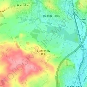
Name: Topografische Karte Stanton by Dale, Höhe, Relief.

Ort: Stanton by Dale, Erewash, Derbyshire, East Midlands, England, United Kingdom (52.93088 -1.34175 52.95275 -1.27882)

Durchschnittliche Höhe: 71 m

Minimale Höhe: 33 m

Maximale Höhe: 134 m

Andere topografische Karten

Klicken Sie auf eine Karte, um ihre Topografie, ihre Höhe und ihr Relief anzuzeigen.

Borrowash

United Kingdom > England > Derbyshire > Erewash

Durchschnittliche Höhe: 59 m

Morley Smithy

United Kingdom > England > Derbyshire > Erewash > Morley

Durchschnittliche Höhe: 113 m

Ilkeston

United Kingdom > England > Derbyshire > Erewash

Durchschnittliche Höhe: 81 m

Ockbrook

United Kingdom > England > Derbyshire > Erewash

Durchschnittliche Höhe: 79 m

Morley Smithy

United Kingdom > England > Derbyshire > Erewash > Morley

Durchschnittliche Höhe: 113 m

Borrowash

United Kingdom > England > Derbyshire > Erewash

Durchschnittliche Höhe: 59 m

Long Eaton

United Kingdom > England > Derbyshire > Erewash

Durchschnittliche Höhe: 31 m

Stanley

United Kingdom > England > Derbyshire > Erewash

The Church gates commemorate Queen Victoria's Golden Jubilee of 1887, and the churchyard contains a memorial (erected in 2004) to the five aircrew who lost their lives when an experimental high-altitude RAF Wellington Bomber disintegrated above Stanley in 1942 following a loss of cabin pressure.

Durchschnittliche Höhe: 100 m

Vielen Dank für die Unterstützung dieser Website ❤️
Spenden

Draycott

United Kingdom > England > Derbyshire > Erewash

Durchschnittliche Höhe: 42 m

West Hallam

United Kingdom > England > Derbyshire > Erewash

Durchschnittliche Höhe: 91 m

Breadsall Hilltop

United Kingdom > England > Derbyshire > Erewash > Breadsall

Durchschnittliche Höhe: 82 m

Derby Canal

United Kingdom > England > Derbyshire > Erewash > Draycott

Durchschnittliche Höhe: 48 m

Stanley Common

United Kingdom > England > Derbyshire > Erewash

Durchschnittliche Höhe: 107 m

Draycott

United Kingdom > England > Derbyshire > Erewash

Durchschnittliche Höhe: 42 m

Ockbrook

United Kingdom > England > Derbyshire > Erewash

Durchschnittliche Höhe: 79 m

Rüsten Sie sich für Ihr nächstes Abenteuer:

🥄Titan-Besteck - Extrem leichtes und stabiles Essbesteck
📊Adventure Buch Tipps - Inspiration & Ratgeber für Outdoor Fans
🧢Outdoor Mütze - Leichte Mütze für kühle Temperaturen
🗺️Topografische Wanderkarten - Gedruckte Regionalkarten für Deutschland im Maßstab 1:25.000
🛌Isomatten - Komfortable Schlafunterlagen für harte Böden

Als Amazon-Partner erhält diese Website eine Provision für qualifizierte Käufe, ohne zusätzliche Kosten für Sie.