
Topografische Karte Palo Duro Canyon State Park
Interaktive Karte
Klicken Sie auf die Karte, um die Höhe anzuzeigen.
Über diese Karte
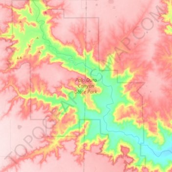
Name: Topografische Karte Palo Duro Canyon State Park, Höhe, Relief.
Ort: Palo Duro Canyon State Park, Randall County, Texas, USA (34.83813 -101.72079 34.98589 -101.56318)
Durchschnittliche Höhe: 980 m
Minimale Höhe: 791 m
Maximale Höhe: 1.079 m
Andere topografische Karten
Klicken Sie auf eine Karte, um ihre Topografie, ihre Höhe und ihr Relief anzuzeigen.
Lake Corpus Christi
Lake Corpus Christi, Lookout Drive, Lagarto, Live Oak County, Texas, USA
Durchschnittliche Höhe: 53 m
Lake Houston
Lake Houston, Pine Cone Drive, Sherwood Trails, Houston, Harris County, Texas, 77339, USA
Durchschnittliche Höhe: 20 m
Point Loma
USA > Texas > Point Loma
Point Loma, San Patricio County, Texas, 78368, USA
Durchschnittliche Höhe: 34 m
High Island
USA > Texas > High Island
High Island, Galveston County, Texas, 77623, USA
Durchschnittliche Höhe: 3 m
Joe Pool Lake
USA > Texas > Cedar Hill
Joe Pool Lake, Lake Ridge Parkway, Cedar Hill, Dallas County, Texas, 75054, USA
Durchschnittliche Höhe: 179 m
Olmos Basin Park
USA > Texas > San Antonio
Olmos Basin Park, San Antonio, Bexar County, Texas, USA
Durchschnittliche Höhe: 227 m
Brushy Creek
USA > Texas > Round Rock
Brushy Creek, Round Rock, Williamson County, Texas, 78680, USA
Durchschnittliche Höhe: 236 m
Whitesboro
USA > Texas > Whitesboro
Whitesboro, Grayson County, Texas, 76273, USA
Durchschnittliche Höhe: 234 m
Leon Creek
USA > Texas > San Antonio
Leon Creek, San Antonio, Bexar County, Texas, 78257, USA
Durchschnittliche Höhe: 349 m
Friedrich Wilderness Park
USA > Texas > San Antonio
Friedrich Wilderness Park, San Antonio, Bexar County, Texas, USA
Durchschnittliche Höhe: 385 m
Cochran's Crossing
USA > Texas > The Woodlands
Cochran's Crossing, The Woodlands, Montgomery County, Texas, 77381, USA
Durchschnittliche Höhe: 50 m
Nueces River
USA > Texas > Corpus Christi
Nueces River, Corpus Christi, Nueces County, Texas, 78410, USA
Durchschnittliche Höhe: 5 m
Devil's River State Natural Area
Devil's River State Natural Area, Dolan Creek Road, Val Verde County, Texas, USA
Durchschnittliche Höhe: 534 m
Stephenson Nature Preserve And Outdoor Education Center
Stephenson Nature Preserve And Outdoor Education Center, West William Cannon Drive, Whispering Oaks, Austin, Travis County, Texas, 78749, USA
Durchschnittliche Höhe: 230 m
Neches River
Neches River, Cherokee County, Texas, 75759, USA
Durchschnittliche Höhe: 108 m
Balcones District Park
Balcones District Park, 12017, North Loop Business Park, Austin, Travis County, Texas, 78759, USA
Durchschnittliche Höhe: 235 m
Baytown Nature Center
Baytown Nature Center, Ridgeway Avenue, Baytown, Harris County, Texas, USA
Durchschnittliche Höhe: 2 m
Heard Natural Science Museum & Wildlife Sanctuary
Heard Natural Science Museum & Wildlife Sanctuary, Wood Duck Trail, McKinney, Collin County, Texas, 75609, USA
Durchschnittliche Höhe: 179 m
Brazos Bend State Park
Brazos Bend State Park, Fort Bend County, Texas, USA
Durchschnittliche Höhe: 17 m
Rummel Creek
Rummel Creek, Houston, Harris County, Texas, TX 77043, USA
Durchschnittliche Höhe: 28 m
Alligator Alley
Alligator Alley, Houston, Harris County, Texas, 773345, USA
Durchschnittliche Höhe: 20 m
River Walk
USA > Texas > San Antonio
River Walk, La Villita, San Antonio, Bexar County, Texas, USA
Durchschnittliche Höhe: 202 m
Armand Bayou Nature Center
Armand Bayou Nature Center, Prairie Interpretive Trail, Pasadena, Harris County, Texas, 77507, USA
Durchschnittliche Höhe: 5 m
Jollyville Plateau
Jollyville Plateau, Austin, Travis County, Texas, 78726, USA
Durchschnittliche Höhe: 297 m
Lake Thunderbird
USA > Texas > Lake Thunderbird
Lake Thunderbird, Bastrop County, Texas, 78965, USA
Durchschnittliche Höhe: 124 m
Piney Point Village
USA > Texas > Piney Point Village
Piney Point Village, Harris County, Texas, 77024, USA
Durchschnittliche Höhe: 25 m
Falcon Creek Park
Falcon Creek Park, McKinney, Collin County, Texas, USA
Durchschnittliche Höhe: 228 m
Lake Texana
Lake Texana, Haynes Road, Manson, Jackson County, Texas, 77962, USA
Durchschnittliche Höhe: 18 m
Big Thicket National Preserve
USA > Texas > Gore Landing
Big Thicket National Preserve, Gore Landing, Jasper County, Texas, USA
Durchschnittliche Höhe: 14 m
Roman Forest
USA > Texas > Roman Forest
Roman Forest, Montgomery County, Texas, USA
Durchschnittliche Höhe: 31 m
Timberlane Acres
USA > Texas > Timberlane Acres
Timberlane Acres, Montgomery County, Texas, 77365, USA
Durchschnittliche Höhe: 29 m
Mountain View Estates
USA > Texas > Mountain View Estates
Mountain View Estates, Bell County, Texas, USA
Durchschnittliche Höhe: 264 m
KIXL-AM (Del Valle)
KIXL-AM (Del Valle), Crofford Lane, Daffan Gin Park, Travis County, Texas, 78724, USA
Durchschnittliche Höhe: 190 m
Aero Vista
USA > Texas > Aero Vista
Aero Vista, El Paso County, Texas, 79908, USA
Durchschnittliche Höhe: 1.196 m
Glenn Heights
USA > Texas > Glenn Heights
Glenn Heights, Dallas County, Texas, USA
Durchschnittliche Höhe: 199 m