
Topografische Karte Olmos Basin Park
Interaktive Karte
Klicken Sie auf die Karte, um die Höhe anzuzeigen.
Über diese Karte
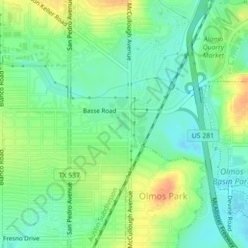
Name: Topografische Karte Olmos Basin Park, Höhe, Relief.
Ort: Olmos Basin Park, San Antonio, Bexar County, Texas, USA (29.48531 -98.49687 29.48805 -98.49179)
Durchschnittliche Höhe: 227 m
Minimale Höhe: 212 m
Maximale Höhe: 248 m
Andere topografische Karten
Klicken Sie auf eine Karte, um ihre Topografie, ihre Höhe und ihr Relief anzuzeigen.
Leon Creek
USA > Texas > San Antonio
Leon Creek, San Antonio, Bexar County, Texas, 78257, USA
Durchschnittliche Höhe: 349 m
Friedrich Wilderness Park
USA > Texas > San Antonio
Friedrich Wilderness Park, San Antonio, Bexar County, Texas, USA
Durchschnittliche Höhe: 385 m
River Walk
USA > Texas > San Antonio
River Walk, La Villita, San Antonio, Bexar County, Texas, USA
Durchschnittliche Höhe: 202 m
Lions Park Lake
USA > Texas > San Antonio
Lions Park Lake, Salado Creek Greenway Trail, San Antonio, Bexar County, Texas, 78222, USA
Durchschnittliche Höhe: 187 m
Lilly Pond
USA > Texas > San Antonio
Lilly Pond, Alpine, Saint Mary's Strip, San Antonio, Bexar County, Texas, 78212, USA
Durchschnittliche Höhe: 221 m
Woodlawn Lake Park
USA > Texas > San Antonio
Woodlawn Lake Park, Monticello Park, San Antonio, Bexar County, Texas, USA
Durchschnittliche Höhe: 215 m