
Topografische Karte Erumely
Interaktive Karte
Klicken Sie auf die Karte, um die Höhe anzuzeigen.
Über diese Karte
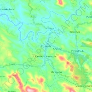
Name: Topografische Karte Erumely, Höhe, Relief.
Ort: Erumely, Kanjirappally, Kottayam, Kerala, 686509, India (9.44137 76.80489 9.52137 76.88489)
Durchschnittliche Höhe: 102 m
Minimale Höhe: 26 m
Maximale Höhe: 309 m
Andere topografische Karten
Klicken Sie auf eine Karte, um ihre Topografie, ihre Höhe und ihr Relief anzuzeigen.
Bhoothakulam
India > Kerala > Kanjirappally > Panamattam
Bhoothakulam, Panamattam, Kanjirappally, Kottayam District, Kerala, India
Durchschnittliche Höhe: 121 m
Manimala
India > Kerala > Kanjirappally
Manimala, Kanjirappally, Kottayam, Kerala, 686543, India
Durchschnittliche Höhe: 65 m
Mukkoottuthara
India > Kerala > Kanjirappally
Mukkoottuthara, Kanjirappally, Kottayam, Kerala, 686510, India
Durchschnittliche Höhe: 159 m
Kanjirappalli
India > Kerala > Kanjirappally
Kanjirappalli, Kanjirappally, Kottayam, Kerala, 686507, India
Durchschnittliche Höhe: 83 m
Chenappady
India > Kerala > Kanjirappally > Chenappady
Chenappady, Kanjirappally, Kottayam, Kerala, 686520, India
Durchschnittliche Höhe: 64 m
Koratty
India > Kerala > Kanjirappally
Koratty, Kanjirappally, Kottayam, Kerala, 686509, India
Durchschnittliche Höhe: 75 m