
Vielen Dank für die Unterstützung dieser Website ❤️
Spenden
Spenden
Rüsten Sie sich für Ihr nächstes Abenteuer:
Als Amazon-Partner erhält diese Website eine Provision für qualifizierte Käufe, ohne zusätzliche Kosten für Sie.
Topografische Karte Manimala
Klicken Sie auf die Karte, um die Höhe anzuzeigen.
Vielen Dank für die Unterstützung dieser Website ❤️
Spenden
Spenden
Rüsten Sie sich für Ihr nächstes Abenteuer:
Als Amazon-Partner erhält diese Website eine Provision für qualifizierte Käufe, ohne zusätzliche Kosten für Sie.
Über diese Karte
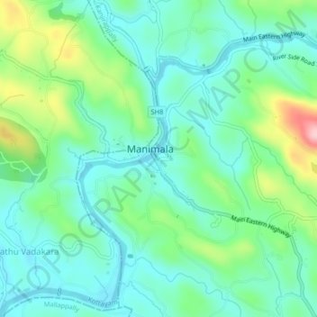
Name: Topografische Karte Manimala, Höhe, Relief.
Ort: Manimala, Kanjirappally, Kottayam, Kerala, 686543, India (9.45416 76.71016 9.53416 76.79016)
Durchschnittliche Höhe: 65 m
Minimale Höhe: 8 m
Maximale Höhe: 218 m
Vielen Dank für die Unterstützung dieser Website ❤️
Spenden
Spenden
Rüsten Sie sich für Ihr nächstes Abenteuer:
Als Amazon-Partner erhält diese Website eine Provision für qualifizierte Käufe, ohne zusätzliche Kosten für Sie.
Andere topografische Karten
Klicken Sie auf eine Karte, um ihre Topografie, ihre Höhe und ihr Relief anzuzeigen.