
Topografische Karte Courmayeur
Interaktive Karte
Klicken Sie auf die Karte, um die Höhe anzuzeigen.
Über diese Karte
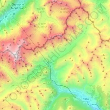
Name: Topografische Karte Courmayeur, Höhe, Relief.
Ort: Courmayeur, Aosta Valley, 11013, Italy (45.74005 6.80153 45.92302 7.10155)
Durchschnittliche Höhe: 2.366 m
Minimale Höhe: 819 m
Maximale Höhe: 4.800 m
At an elevation of 1,224 m (4,016 ft) above sea level, it is located at the foot of the southern side of Mont Blanc, at 4,810 m (15,781 ft) the highest point in the Alps and western Europe (see Seven Summits), and is crossed by the Dora Baltea (fr. Doire baltée) river.
Andere topografische Karten
Klicken Sie auf eine Karte, um ihre Topografie, ihre Höhe und ihr Relief anzuzeigen.
Oley
Italy > Aosta Valley > Montjovet
Oley, Montjovet, Aosta Valley, 11029, Italy
Durchschnittliche Höhe: 809 m
Monte Rosa Massif
Italy > Aosta Valley > Gressoney-La-Trinité
Monte Rosa Massif, Gressoney-La-Trinité, Aosta Valley, Italy
Durchschnittliche Höhe: 3.478 m
Vetan Villette
Italy > Aosta Valley > Saint-Pierre
Vetan Villette, Saint-Pierre, Aosta Valley, 11011, Italy
Durchschnittliche Höhe: 1.722 m
Brengon
Italy > Aosta Valley > La Magdeleine
Brengon, La Magdeleine, Aosta Valley, Italy
Durchschnittliche Höhe: 1.755 m
Maé
Italy > Aosta Valley > Challand-Saint-Anselme
Maé, Challand-Saint-Anselme, Aosta Valley, 11022, Italy
Durchschnittliche Höhe: 1.416 m
Moulin
Italy > Aosta Valley > Ruvere
Moulin, Ruvere, Antey-Saint-André, Aosta Valley, 11020, Italy
Durchschnittliche Höhe: 1.410 m
Le Pont
Italy > Aosta Valley > Valsavarenche
Le Pont, Valsavarenche, Aosta Valley, Italy
Durchschnittliche Höhe: 2.410 m
Creton
Creton, Etroubles, Aosta Valley, 11014, Italy
Durchschnittliche Höhe: 1.681 m
Merlin
Merlin, Châtillon, Aosta Valley, 11024, Italy
Durchschnittliche Höhe: 792 m
Larzey
Italy > Aosta Valley > Courmayeur
Larzey, Courmayeur, Aosta Valley, 11013, Italy
Durchschnittliche Höhe: 1.596 m
Gimiod
Italy > Aosta Valley > Bovaye > Gimiod
Gimiod, Bovaye, Pontey, Aosta Valley, 11024, Italy
Durchschnittliche Höhe: 1.014 m
Mont Blanc - Monte Bianco
Italy > Aosta Valley > Courmayeur
Mont Blanc - Monte Bianco, Sentiero per Rifugio Monzino, Courmayeur, Aosta Valley, Italy
Durchschnittliche Höhe: 4.092 m
La Palud
Italy > Aosta Valley > Courmayeur > La Palud
La Palud, Courmayeur, Aosta Valley, 11013, Italy
Durchschnittliche Höhe: 1.729 m
Batse
Italy > Aosta Valley > Breuil-Cervinia > Batse
Batse, Breuil-Cervinia, Valtournenche, Aosta Valley, 11021, Italy
Durchschnittliche Höhe: 2.526 m
Val Veny
Italy > Aosta Valley > Courmayeur
Val Veny, Courmayeur, Aosta Valley, Italy
Durchschnittliche Höhe: 2.151 m
Torrente
Italy > Aosta Valley > Bionaz
Torrente, Bionaz, Aosta Valley, Italy
Durchschnittliche Höhe: 2.448 m
Aymavilles
Italy > Aosta Valley > Aymavilles
Aymavilles, Aosta Valley, Italy
Durchschnittliche Höhe: 1.830 m
Champdepraz
Italy > Aosta Valley > Champdepraz
Champdepraz, Aosta Valley, 11023, Italy
Durchschnittliche Höhe: 1.233 m
Ghiacciaio del Miage
Italy > Aosta Valley > Courmayeur
Ghiacciaio del Miage, Sentiero 15 Rifugio Gonella, Courmayeur, Aosta Valley, Italy
Durchschnittliche Höhe: 2.911 m
Dent d'Hérens
Italy > Aosta Valley > Bionaz
Dent d'Hérens, Bionaz, Aosta Valley, Italy
Durchschnittliche Höhe: 3.354 m
Gran Paradiso
Italy > Aosta Valley > Valsavarenche
Gran Paradiso, Valsavarenche, Aosta Valley, Italy
Durchschnittliche Höhe: 3.459 m