
Topografische Karte Ghiacciaio del Miage
Interaktive Karte
Klicken Sie auf die Karte, um die Höhe anzuzeigen.
Über diese Karte
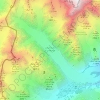
Name: Topografische Karte Ghiacciaio del Miage, Höhe, Relief.
Durchschnittliche Höhe: 2.911 m
Minimale Höhe: 1.797 m
Maximale Höhe: 4.737 m
Andere topografische Karten
Klicken Sie auf eine Karte, um ihre Topografie, ihre Höhe und ihr Relief anzuzeigen.
Larzey
Italy > Aosta Valley > Courmayeur
Larzey, Courmayeur, Aosta Valley, 11013, Italy
Durchschnittliche Höhe: 1.596 m
Mont Blanc - Monte Bianco
Italy > Aosta Valley > Courmayeur
Mont Blanc - Monte Bianco, Sentiero per Rifugio Monzino, Courmayeur, Aosta Valley, Italy
Durchschnittliche Höhe: 4.092 m
Val Veny
Italy > Aosta Valley > Courmayeur
Val Veny, Courmayeur, Aosta Valley, Italy
Durchschnittliche Höhe: 2.151 m