
Topografische Karte San Pedro
Interaktive Karte
Klicken Sie auf die Karte, um die Höhe anzuzeigen.
Über diese Karte
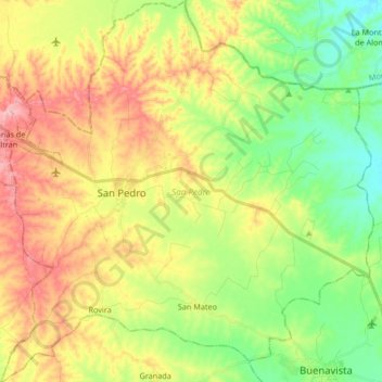
Name: Topografische Karte San Pedro, Höhe, Relief.
Ort: San Pedro, Sabanas, Sucre, Colombia (9.31444 -75.11669 9.47887 -74.95382)
Durchschnittliche Höhe: 126 m
Minimale Höhe: 55 m
Maximale Höhe: 219 m
Andere topografische Karten
Klicken Sie auf eine Karte, um ihre Topografie, ihre Höhe und ihr Relief anzuzeigen.
San Antonio
Colombia > Sucre > San Antonio
San Antonio, San Onofre, Sucre, Colombia
Durchschnittliche Höhe: 7 m
Las Brisas
Colombia > Sucre > Las Brisas
Las Brisas, San Onofre, Sucre, Colombia
Durchschnittliche Höhe: 70 m
El Tamarindo
Colombia > Sucre > El Tamarindo
El Tamarindo, Los Palmitos, Sucre, Colombia
Durchschnittliche Höhe: 194 m