
Topografische Karte Sucre
Interaktive Karte
Klicken Sie auf die Karte, um die Höhe anzuzeigen.
Über diese Karte
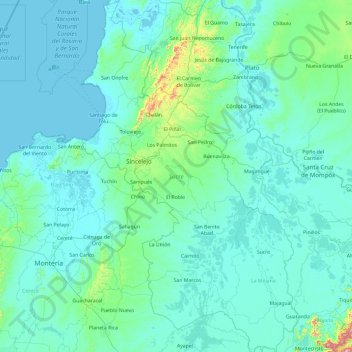
Name: Topografische Karte Sucre, Höhe, Relief.
Ort: Sucre, Caribe, Colombia (8.27605 -75.71177 10.14849 -74.53289)
Durchschnittliche Höhe: 69 m
Minimale Höhe: -2 m
Maximale Höhe: 1.550 m
Andere topografische Karten
Klicken Sie auf eine Karte, um ihre Topografie, ihre Höhe und ihr Relief anzuzeigen.
San Antonio
Colombia > Sucre > San Antonio
San Antonio, San Onofre, Sucre, Colombia
Durchschnittliche Höhe: 7 m
Las Brisas
Colombia > Sucre > Las Brisas
Las Brisas, San Onofre, Sucre, Colombia
Durchschnittliche Höhe: 70 m
El Tamarindo
Colombia > Sucre > El Tamarindo
El Tamarindo, Los Palmitos, Sucre, Colombia
Durchschnittliche Höhe: 194 m