Geolokalisieren

Topografische Karte Hamilton Township

Klicken Sie auf die Karte, um die Höhe anzuzeigen.

👉 Easily get elevation data in JSON, GeoTIFF and KML formats using Elevation API
Vielen Dank für die Unterstützung dieser Website ❤️
Spenden

Rüsten Sie sich für Ihr nächstes Abenteuer:

Als Amazon-Partner erhält diese Website eine Provision für qualifizierte Käufe, ohne zusätzliche Kosten für Sie.

Über diese Karte

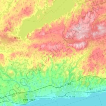
Name: Topografische Karte Hamilton Township, Höhe, Relief.

Ort: Hamilton Township, Northumberland County, Central Ontario, Ontario, Canada (43.93750 -78.34658 44.17248 -78.07972)

Durchschnittliche Höhe: 192 m

Minimale Höhe: 70 m

Maximale Höhe: 355 m

👉 Easily get elevation data in JSON, GeoTIFF and KML formats using Elevation API
Vielen Dank für die Unterstützung dieser Website ❤️
Spenden

Andere topografische Karten

Klicken Sie auf eine Karte, um ihre Topografie, ihre Höhe und ihr Relief anzuzeigen.

Campbellford

Canada > Ontario > Northumberland County > Trent Hills

Durchschnittliche Höhe: 174 m

Vernonville

Canada > Ontario > Northumberland County > Alnwick/Haldimand

Durchschnittliche Höhe: 196 m

Pethericks Corners

Canada > Ontario > Northumberland County > Trent Hills

Durchschnittliche Höhe: 181 m

Alderville

Canada > Ontario > Northumberland County

Durchschnittliche Höhe: 259 m

Vielen Dank für die Unterstützung dieser Website ❤️
Spenden

Trent River

Canada > Ontario > Northumberland County > Trent Hills

Durchschnittliche Höhe: 138 m

Morganston

Canada > Ontario > Northumberland County > Cramahe

Durchschnittliche Höhe: 169 m

Warkworth

Canada > Ontario > Northumberland County > Trent Hills

Durchschnittliche Höhe: 165 m

Bewdley

Canada > Ontario > Northumberland County > Hamilton Township

Durchschnittliche Höhe: 204 m

Vielen Dank für die Unterstützung dieser Website ❤️
Spenden

Rüsten Sie sich für Ihr nächstes Abenteuer:

Als Amazon-Partner erhält diese Website eine Provision für qualifizierte Käufe, ohne zusätzliche Kosten für Sie.

Colborne

Canada > Ontario > Northumberland County > Cramahe

Durchschnittliche Höhe: 114 m

Trent River

Canada > Ontario > Northumberland County > Trent Hills > Trent River

Durchschnittliche Höhe: 197 m

Camborne

Canada > Ontario > Northumberland County > Hamilton Township > Camborne

Durchschnittliche Höhe: 196 m

Baltimore

Canada > Ontario > Northumberland County > Hamilton Township

Durchschnittliche Höhe: 176 m

Zion

Canada > Ontario > Northumberland County > Port Hope

Durchschnittliche Höhe: 182 m

Hastings

Canada > Ontario > Northumberland County > Trent Hills

Durchschnittliche Höhe: 207 m

Campbellcroft

Canada > Ontario > Northumberland County > Port Hope

Durchschnittliche Höhe: 207 m

Garden Hill

Canada > Ontario > Northumberland County > Port Hope

Durchschnittliche Höhe: 198 m

Ganaraska River

Canada > Ontario > Northumberland County > Port Hope

Durchschnittliche Höhe: 173 m

O'Reilly Lake

Canada > Ontario > Northumberland County > Trent Hills

Durchschnittliche Höhe: 220 m

Vielen Dank für die Unterstützung dieser Website ❤️
Spenden

Rüsten Sie sich für Ihr nächstes Abenteuer:

Als Amazon-Partner erhält diese Website eine Provision für qualifizierte Käufe, ohne zusätzliche Kosten für Sie.

Percy Boom

Canada > Ontario > Northumberland County > Trent Hills

Durchschnittliche Höhe: 127 m

Castleton

Canada > Ontario > Northumberland County > Cramahe

Durchschnittliche Höhe: 200 m

Burnley Creek

Canada > Ontario > Northumberland County > Trent Hills

Durchschnittliche Höhe: 213 m

Hardy Island

Canada > Ontario > Northumberland County > Trent Hills

Durchschnittliche Höhe: 187 m

Vielen Dank für die Unterstützung dieser Website ❤️
Spenden

Rüsten Sie sich für Ihr nächstes Abenteuer:

Als Amazon-Partner erhält diese Website eine Provision für qualifizierte Käufe, ohne zusätzliche Kosten für Sie.

Cold Springs

Canada > Ontario > Northumberland County > Hamilton Township

Durchschnittliche Höhe: 249 m

Grafton

Canada > Ontario > Northumberland County > Alnwick/Haldimand

Durchschnittliche Höhe: 124 m

Colborne

Canada > Ontario > Northumberland County > Cramahe

Durchschnittliche Höhe: 114 m

Rüsten Sie sich für Ihr nächstes Abenteuer:

🛰️GPS-Handgeräte - Robuste Navigationsgeräte für Wanderungen und Expeditionen
👟Trail Socken - Spezialsocken für Trailrunning
🧼Biologische Outdoor-Seife - Umweltfreundliche Hygiene für unterwegs
📷Action Kamera - Robuste Kamera für Outdoor‑Aufnahmen
🔭Ferngläser 8x42 - Der Allrounder für Natur- und Geländebeobachtung

Als Amazon-Partner erhält diese Website eine Provision für qualifizierte Käufe, ohne zusätzliche Kosten für Sie.