Geolokalisieren

Topografische Karte Zion

Interaktive Karte

Klicken Sie auf die Karte, um die Höhe anzuzeigen.

Über diese Karte

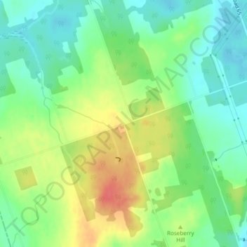
Name: Topografische Karte Zion, Höhe, Relief.

Ort: Zion, Port Hope, Northumberland County, Central Ontario, Ontario, L1A 3V7, Canada (43.95990 -78.44949 43.97990 -78.42949)

Durchschnittliche Höhe: 182 m

Minimale Höhe: 158 m

Maximale Höhe: 218 m

Andere topografische Karten

Klicken Sie auf eine Karte, um ihre Topografie, ihre Höhe und ihr Relief anzuzeigen.

Ganaraska River

Canada > Ontario > Northumberland County > Port Hope

Ganaraska River, Port Hope, Northumberland County, Central Ontario, Ontario, Canada

Durchschnittliche Höhe: 173 m

Garden Hill

Canada > Ontario > Northumberland County > Port Hope

Garden Hill, Port Hope, Northumberland County, Central Ontario, Ontario, L0A 1B0, Canada

Durchschnittliche Höhe: 198 m

Campbellcroft

Canada > Ontario > Northumberland County > Port Hope

Campbellcroft, Port Hope, Northumberland County, Central Ontario, Ontario, Canada

Durchschnittliche Höhe: 207 m